Waterside Mapping in Italy
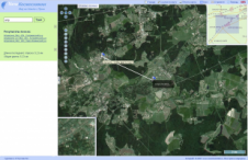
The combination of 3D-laser scanning and side-scan sonar can be very beneficial for mapping complicated waterside areas; the two systems are complementary. High-resolution surveys were performed over a two-year period...
The combination of 3D-laser scanning and side-scan sonar can be very beneficial for mapping complicated waterside areas; the two systems are complementary. High-resolution surveys were performed over a two-year period...
Following an extensive examination and evaluation, the Applanix Airborne Digital Sensor System (DSS) has been granted full manufacturer certification by the United States Geological Survey (USGS). With this acknowledgment, the...
TerraGo Technologie (GA, USA) has released MAP2PDF for GeoTIFF, allowing TerraGo customers to create GeoPDF files directly from GeoTIFF files. These GeoPDF files are then viewable with the free Adobe...
At the end of the tumultuous eighteenth century the British government ordered its Board of Ordnance, the defence ministry of its day, to survey the country’s south coast. Today Ordnance...
Applanix (Canada) has announced the release of POSPac AIR 4.3, the latest update to its airborne data post-processing software. Developed for the aerial survey and remote sensing industry, the customided...
Applied Imagery (MD, USA) has upgraded its QT Modeler software and changed the product name to Quick Terrain Modeler. Applied Imagery’s diverse user base provides valuable suggestions and has shaped...

Magellan Z-Max.Net has has been qualified for the new French GPS Reference Network Teria. Originally planned by the Ordre des Géomètres-Experts (French Surveyors Union) to facilitate the work of its...
A new site has been launched as the first stage of the project to create satellite-based imagery database covering the entire Russian territory. These images can be viewed as a...
Intergraph Corporation (AL, USA) has released ImageStation PixelQue, an application offering several finishing tools needed in orthophoto production for image inspection, quality control, image enhancement, and image editing. ImageStation PixelQue...
Applanix (Canada) has introduced a new GNSS receiver option for its airborne vehicle position and orientation system, POS AV, which fully supports both GPS and Glonass signals. Raw data can...
This site uses cookies. By continuing to use this website, you agree to our Cookies Policy. Agree