Konstantinos Karantzalos
Konstantinos Karantzalos received the engineering diploma degree from the National Technical University of Athens (NTUA), Athens, Greece, and a PhD in 2007 from NTUA in collaboration with CERTIS, Ecole Nationale...

Konstantinos Karantzalos received the engineering diploma degree from the National Technical University of Athens (NTUA), Athens, Greece, and a PhD in 2007 from NTUA in collaboration with CERTIS, Ecole Nationale...
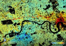
In a groundbreaking revolution, modern InSAR is now used by a range of industries concerned with ground or structural stability. So what are the key aspects of InSAR technology? And...
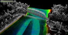
H2H Geoscience Engineering (H2H) has announced a new contract with Albany Water Board, providing topographic and bathymetric surveying services for their two reservoirs – Alcove and Basic Creek in Albany...
Canada’s Pollutant Inventories and Reporting Division (PIRD) faces the massive task of creating a greenhouse gas inventory for the entire nation. A key part of this analysis is the use...
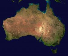
The Australasian region took a major step towards gaining its first-ever satellite-based augmentation system (SBAS) in early 2017. That is when the governments of Australia and New Zealand agreed to...
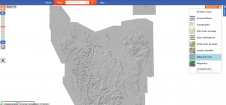
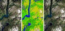
A beta version Digital Elevation Model (DEM) has been constructed for Tasmania (Australia) by MRT geoscientists Dr Claire Kain and Colin Mazengarb, including the most recent Lidar imagery captured during the...
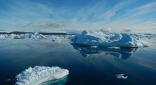
According to new research, the Arctic’s oldest and thickest ice is more mobile than ice in the rest of the Arctic and is vanishing twice as fast. Researchers have identified...
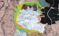
NPA Satellite Mapping, part of CGG’s Geoscience Division, has launched MineScope, a suite of satellite-derived services that enable mining companies and third-party consultants to make smarter geological, geotechnical and safety-related...

Unmanned aerial vehicles (UAVs or ‘drones’) have become popular instruments for a wide range of emerging applications such as mapping, search & rescue, infrastructure monitoring, precision farming, transport of goods...
The use of data from Landsat satellites has become a cornerstone of global land imaging with broad societal benefits. More real-time monitoring capability in the future will further our understanding...
This site uses cookies. By continuing to use this website, you agree to our Cookies Policy. Agree