Geospatial Data Webinar
East View Cartographic is organising a webinar in which we will provide participants with tools needed to fully utilise geospatial data available. The event is to take place on Thursday...
East View Cartographic is organising a webinar in which we will provide participants with tools needed to fully utilise geospatial data available. The event is to take place on Thursday...
Groupe Alta and Integrated Mapping Technologies have started a strategic alliance to integrate Web diffusion solutions and recurrent aerial acquisition programs to streamline distribution of high-precision geospatial data in British...
The OGC (MD, USA) Technical Committee's Spatial Data Quality Working Group (WG) has been gathering information and requirements from OGC members for the past year and has now begun primary...

Lidaretto is flexible and compact Lidar scanning system developed since 2015 and uniquely designed to be used the way that fits best to users’ specific application. You can easily mount...

From 10 to 12 October, the vibrant capital city of Germany will be the epicentre of geoinformation innovation as it hosts Intergeo Expo and Conference. With a rich array of...
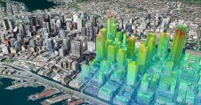
Thanks to the ability of digital twins to provide insights into the reality of present conditions and the impacts of future scenarios, they have the potential to revolutionize the planning...

In a groundbreaking collaboration, Genesys International and Survey of India (SOI) have formed a strategic alliance to create digital twins of major cities and towns. This partnership is aimed at...
Cloudeo, a one-stop shop for geospatial solutions, has partnered with Globhe, a drone-as-a-service company, to expand its geospatial products offered through the Cloudeo marketplace. The partnership will introduce drone data...
Calling all geospatial professionals! You’ve no doubt been involved in inspiring projects and applications that leverage innovative reality capture methods and advanced technologies. In the spirit of knowledge exchange, why...

Celebrating four decades as a pioneering force in the UK and Ireland's geospatial industry, Murphy Geospatial has unveiled its innovative mobile-mapping solution called GeoDrive. This groundbreaking technology enables the collection...
This site uses cookies. By continuing to use this website, you agree to our Cookies Policy. Agree