Aerial Imaging Solutions
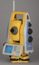
Topcon's Imaging Station, the IS-3, increases the longest scanning range to 6,500 feet (2,100m). Its patented prism tracking scanning interface technology X-TRAC 8 has, according to senior vice president of...
CGGVeritas has inaugurated a new open Processing & Imaging center in Muscat, Oman at a ceremony attended by clients and a delegation from the Omani Ministry of Oil & Gas....

The Trimble MX8 Mobile Spatial Imaging System is an advanced mobile data capture system that combines imaging and laser scanning capabilities to measure objects in 3D to produce 3D, 4D...
Trimble Access software for Spatial Imaging is an addition to Trimble's Connected Site solutions. Trimble Access is a streamlined field and office solution for surveyors and geospatial professionals that expedites...
Vexcel Imaging GmbH has selected Imagemaps as its sales representative responsible for the People's Republic of China, Taiwan, Australia, New Zealand and ASEAN (Singapore, Malaysia, Indonesia, Brunei, Thailand, Philippines, Vietnam,...

Vexcel Imaging is a global leader in aerial imaging, known for developing cutting-edge aerial cameras, mapping systems, and photogrammetric processing software. The UltraCam 4th generation system lineup includes the high-precision...
This site uses cookies. By continuing to use this website, you agree to our Cookies Policy. Agree