Using AI for good
Humanitarian organizations turned to artificial intelligence (AI) to generate a comprehensive map of sub-Saharan Africa at scale and also keep it updated to reflect real-world changes. Geospatial analysis is a...
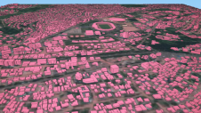
Humanitarian organizations turned to artificial intelligence (AI) to generate a comprehensive map of sub-Saharan Africa at scale and also keep it updated to reflect real-world changes. Geospatial analysis is a...

Through the National Registry Center (CNR), the government of El Salvador is embarking on a large-scale project to map the complete country (an area of 20,742km2), with the 14 departmental...

To provide all Beninese citizens the right to access land, bring economic prosperity and prevent land-related disputes, the Beninese government aims to establish a nationwide digital land administration system. With...

Intermap Technologies, a global leader in 3D geospatial products and intelligence solutions, has been contracted to provide its high-resolution NEXTMap elevation data and precision radar imagery to support the United...
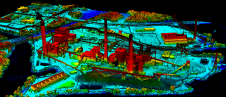
Energy Queensland has placed its trust in Fugro to fortify its powerline infrastructure, as the latter secures a three-year contract to provide Roames solutions in Australia. Serving communities across the...

As the host city of Intergeo 2023 this October, Berlin promises to deliver the perfect kick-start for the geospatial industry in these rapidly changing times. The vibrant German capital is...
Woolpert has been contracted to collect high-density Lidar data for more than 17,500 square kilometres of rural Texas to map electrical distribution poles and wires along with surrounding natural and...
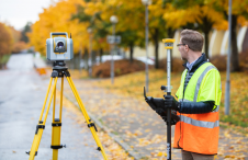
Although the essence of surveying has barely changed since the profession began, the increasingly complex digital continuum requires geospatial professionals to adapt their skills in dynamic and important ways, writes...
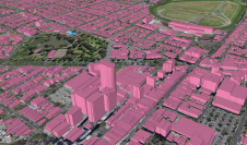
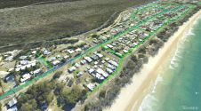
Ecopia AI and Woolpert have expanded their partnership to map Australia’s top metropolitan areas in 3D. The resulting vector maps will provide Woolpert’s Asia-Pacific clients with a detailed, accurate and...

DEA Aviation, a technology-led aerial data acquisition company, has completed the first stage of a trial using sustainable aviation fuel (SAF) with Ordnance Survey (OS), the national mapping service for...
This site uses cookies. By continuing to use this website, you agree to our Cookies Policy. Agree