Land Surveys
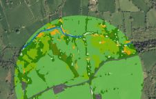
The UK's Environmental Protection Agency (EPA) and Tailte Éireann (formerly known as the Ordnance Survey of Ireland) have collaborated to launch a groundbreaking National Land Cover Map of Ireland. The...

Over the past 15 years, geospatial information has enabled the transformation of towns, cities and a whole state in Mexico. The customer and data provider teamed up to create up-to-date...

Juan Partida is CFO of the government of Jalisco, having been a public servant for the last 15 years. From the outset, his involvements have included modernizing and designing cadastral...
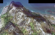
The UK’s Peak District National Park Authority is pioneering the use of artificial intelligence (AI) to automate the production of highly detailed land cover maps, in a project in partnership...
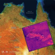
UP42 and OroraTech have signed a partnership agreement to grant easy and fast access to global high-resolution thermal-infrared imagery. UP42 is a geospatial developer platform and marketplace, and OroraTech is...
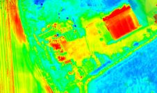
Topodrone has recently unveiled a cutting-edge drone thermal mapping solution: the Topodrone PT61 camera, designed to conduct detailed surveys and generate thermal orthomosaic maps, facilitating the creation of accurate 3D...

Cadastre & Land Administration Geospatial data obviously is key to sustainable land management. But what are the common success factors for land administration and cadastral systems around the world? In this issue, we will...
This site uses cookies. By continuing to use this website, you agree to our Cookies Policy. Agree
