
Cartomorphosis: an evolution that starts with cadastre
To govern or not to govern? Territory is the question!
Over the past 15 years, geospatial information has enabled the transformation of towns, cities and a whole state in Mexico. The customer and data provider teamed up to create up-to-date datasets to enable municipalities to enhance their finances through assertive land-management public policies. For this Mexican region, modernizing cadastres has been the first step towards achieving public financial freedom and empowering multidisciplinary decisions through maps.
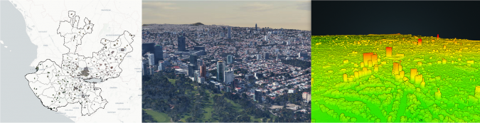
In 2010, Juan Partida was appointed CFO as part of the new government of Tlajomulco. This 716km2 municipality is part of Jalisco, Mexico’s third-largest state (by GDP) comprising 80,000km2 and 125 municipalities in total. The government officials received a mapless cadastre of alphanumerical registries, ten-year-old aerial photographs and some paper-based property outlines. The municipality was in dire need of fresh resources to fund the modernization of its administrative capabilities to keep up with the fast-paced land development in its territory. It used federal programmes to finance a geospatial dataset, software and restructured processes. The dataset, the first of its kind in Mexico, included aerial vertical and oblique imagery at 10cm ground sample distance (GSD), mobile mapping and was one of the first to use uncrewed aerial vehicles (UAVs or ‘drones’) for micro-coverage updates.
The entire dataset was made available to the cadastral office and the rest of the municipal areas through eCarto, CartoData’s web mapping platform. Each municipal area had its own eCartoApp, allowing the property ID to be the primary key to every municipal transaction based on cross-checking with other areas for its validity and eligibility. To date, 183 apps and maps provide a governing framework enabling team collaboration through a common shared context: the territory. Apps range from cadastral and general land management all the way to security dispatch,garbage collection, weather monitoring, disaster management and restoration of public space. 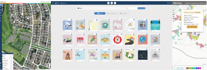
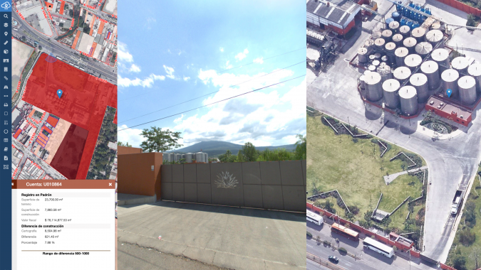
Interdisciplinary workflows were also put in place. Every time the dataset gets updated, scripted routines now validate the amount of built square metres in a property versus the ones in the registry. In the case of a mismatch, the system cascades to building permit verification, updates the cadastral registry and triggers an inspection while disabling any additional commercial or construction permits. Intertwining data, software and processes into a coordinated effort held the key to making this happen. This resulted in a four-fold increase in revenue linked to land registry over a five-year period, improved financial health, stronger credit ratings (S&P and Fitch) and numerous awards such as the Geospatial Latin American Award for best cadastral system and the most innovative organization in the public sector in 2018.
Replicating and scaling up
The state of Jalisco, within which Tlajomulco is located, had historically acquired aerial photographs of the state’s most relevant towns roughly every ten years,. These remained in the archives and rarely made it beyond the desks of specific cadastral experts. When Partida changed offices, he became aware of the situation. The team decided to replicate Tlajomulco’s platform by treating each municipality as an independent entity with access to all of its historical data, all the way back to 1967. The archives were digitized and made available along with an updated dataset acquired in 2020. The new dataset included 10cm GSD imagery, oblique images and Lidar data. The state bore the costs of acquiring and processing the new dataset, providing municipalities with the rare opportunity to capitalize on fresh geospatial information at minimal cost.
Grasping the low-hanging fruit in Tequila
Tequila, home to the eponymous spirit, was one of the municipalities that exploited Jalisco’s data, Tlajomulco’s experience and CartoData’s manpower. In a record six weeks, it implemented the cadastral system on eCarto and increased net tax revenue by an impressive 232% in just two years. This was partly due to the fact that many tequila- manufacturing facilities had been registered as sheds or plantations, resulting in missed tax collections spanning several decades. The added revenue helped break a long-standing vicious circle of poor public services due to weak municipal finances.
A self-financed first step towards a smart city
Latin American urban planning is quite different from American or European models; it is more chaotic and has an abundance of informal settlements, making cadastral tasks challenging in nature. Thanks to the cumulative experiences gathered over the last 15 years of continuously assisting governments in Mexico navigate the ins and outs of cadastral dataset modernization and design, it has been possible to continuously tailor and streamline the Cartomorphosis framework. So far, CartoData has implemented it at different levels in over 63 municipalities and two countries, including El Salvador. If the aim is to design a smart city, the first building block is to have a cadastral dataset that approximates reality as closely as possible and is constantly updated by daily transactions. While dataset modernization can sometimes require sizable investments of time and money, these investments quickly pay for themselves several times over, whether in terms of higher tax revenues, better control of land resources, or because they generate useful data to bolster various other public services.
Further reading
How El Salvador empowered growth and efficiency through mapping

Value staying current with geomatics?
Stay on the map with our expertly curated newsletters.
We provide educational insights, industry updates, and inspiring stories to help you learn, grow, and reach your full potential in your field. Don't miss out - subscribe today and ensure you're always informed, educated, and inspired.
Choose your newsletter(s)


