Continuous Mobile Laser Scanning
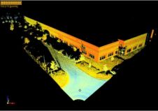
Combining Terrestrial Laser Scanning, Position and Orientation Systems and GPS receivers into a mobile mapping system enables effective mapping of large and complex terrain. The authors tested a mobile mapping...
Combining Terrestrial Laser Scanning, Position and Orientation Systems and GPS receivers into a mobile mapping system enables effective mapping of large and complex terrain. The authors tested a mobile mapping...
Terrestrial 3D laser scanning will become the future standard tool for high-resolution 3D documentation of archaeological excavations, but its capabilities are still underestimated by professional archaeologists and providers of scanners...
The March issue of GIM International carried the response of manufacturers of laser-scanning sensors and software to remarks made in the Insider’s View column on shortcomings of this technology in...
In this month’s Insider’s View Prof. Heinz Rüther puts some critical points on the shortcomings of laser-scanning technology in the spatial documentation of heritage sites. We invited manufacturers of laser-scanning...
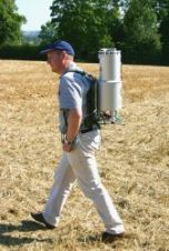
3D Laser Mapping (UK) has developed a portable laser scanning system for mapping overhead infrastructure such as power lines. With adverse weather and over-grown vegetation increasingly causing damage to overhead...
Topcon Positioning Systems (TPS) has announced the release of ScanMaster 2.0 software which is developed to be faster and more powerful than previous versions. The software streamlines the data processing...

RIEGL has announced the launch of two innovative topobathymetric scanners. These advancements mark a shift towards enhanced efficiency and precision in data collection across land and water interfaces. The RIEGL...
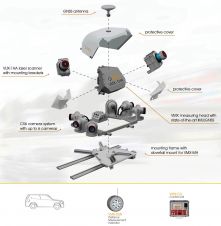
Trimble has recently announced the Trimble X9 3D laser scanning system, a versatile reality capture solution for surveying, construction and engineering professionals. The X9 is built on Trimble's proven laser...
The demand for 3D maps of cities and road networks is steadily increasing and mobile mapping systems are often the preferred acquisition method for capturing such scenes. Manual processing of...
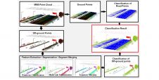
The demand for 3D maps of cities and road networks is steadily increasing and mobile mapping systems are often the preferred geodata acquisition method for capturing such scenes. Manual processing...
This site uses cookies. By continuing to use this website, you agree to our Cookies Policy. Agree