Vexcel Acquires Synoptics
Vexcel Corporation (CO, USA) has announced that it recently acquired the assets of Synoptics, a Netherlands-based remote sensing company and provider of satellite-based geo information and GIS. The acquisition makes...
Vexcel Corporation (CO, USA) has announced that it recently acquired the assets of Synoptics, a Netherlands-based remote sensing company and provider of satellite-based geo information and GIS. The acquisition makes...
GIS Solutions (IL, USA) and ESRI (CA, USA) were selected by the Illinois Department of Agriculture (IDOA) to develop GIS tools that will improve the effectiveness of a coordinated response...
RADARSAT International (Canada) has announced that it has signed US$ 1.54 million in network station licensing and renewal agreements. New network stations include the Nato Undersea Research Centre (NURC) of...
Thales (CA, USA) has announced that Topométrica Lda., a distributor of survey equipment in Portugal, has signed an agreement to distribute both the GIS and Land Survey product lines of...
The 12th Brazilian Remote Sensing Symposium (SBSR) was held in the Convention Center, Goiânia, Goiás State Capital from 17th to 21st April 2005. This was the biggest symposium since the...
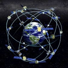
Receiver position is calculated from the position of satellites and the distances to them. Distance is calculated from the time a radio signal travels between satellite and receiver. But how...
The first International Symposium on Geo-information for Disaster Management (Gi4DM) was held at Delft University of Technology, The Netherlands from 21st to 23rd March 2005. More than three hundred participants...
The last quarter century has seen a stupendous development in the field of global positioning technology and today it is almost a taken for granted service by a global positional...
STAR INFORMATIC (Belgium) has announced that its STAR-ELEC application for electricity network management has been selected by the Office National de l’Electricité in Morocco (O.N.E.). This contract aims to facilitate...
Administrative reform within Europe has had a tremendous impact on land administration all over the continent. Geo-Spatial Data Infrastructures (GSDI) may bring further improvements. The authors review land policy, land...
This site uses cookies. By continuing to use this website, you agree to our Cookies Policy. Agree