Near-Real Time Access at GEOINT 2009
The Carbon Project is to bring its near-real time geospatial access solutions to the GEOINT 2009 symposium held this week in San Antonio, Texas. The Gaia SDI platform will be...
The Carbon Project is to bring its near-real time geospatial access solutions to the GEOINT 2009 symposium held this week in San Antonio, Texas. The Gaia SDI platform will be...
Sensaris is reporting the first trial for its environmental sensor series. Air pollution is one of the most important factors affecting the quality of life and the health of the...
Leica GeoMoS Web is a web-based service for visualisation and analysis of monitoring via internet. Each authorized user, including customers and partners, can access the monitoring project anywhere and anytime...

NAVTEQ has completed its acquisition of T-Systems Traffic. The acquisition marks a significant step in NAVTEQ\'s program to expand its traffic offering in Europe. T-Traffic is a provider of traffic...

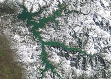
The Icelandic authorities have commissioned Acecore to map the extent and aftermath of the Eldvörp-Svartsengi volcanic system eruption using its high-end drone solutions. Grindavík, a fishing village on the Reykjanes...
Trimble has unveiled the integration of the Trimble Applanix POSPac Cloud post-processed kinematic (PPK) GNSS positioning service, featuring CenterPoint RTX, with the UAV-based mapping and data collection capabilities of DroneDeploy’s reality...
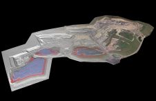
At Geo Week 2024 in Denver, Maptek unveiled its latest innovation: Maptek GeoSpatial Manager. This groundbreaking solution simplifies and streamlines workflows, revolutionizing how mining and civil engineering projects manage data...
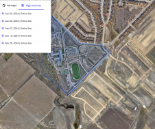
PlanetScope is now accessible on Google Cloud Marketplace. This availability of Planet's flagship satellite imaging product contributes to the company's mission to democratize access to near-daily satellite imagery, enabling organizations...

Wingtra has unveiled its innovative Lidar-drone solution. The new Lidar payload is designed to seamlessly integrate the efficiency, ease of operation, and high accuracy of the WingtraOne GEN II drones...

There are indications that today’s technological advances are putting a fully operational multipurpose cadastre within reach, following decades of a global vision and small-scale progress towards a comprehensive map-centric land...
This site uses cookies. By continuing to use this website, you agree to our Cookies Policy. Agree