UAV Remote Sensing for Smart Agriculture
‘Smart agriculture’, i.e. the efficient use of Earth's resources to feed the world, requires accurate and advanced data acquisition, modelling and management. UAVs can play a critical role in this....
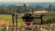
‘Smart agriculture’, i.e. the efficient use of Earth's resources to feed the world, requires accurate and advanced data acquisition, modelling and management. UAVs can play a critical role in this....
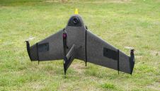
Atmos UAV, a leading innovator in the VTOL mapping drone industry, is excited to announce the integration of the new Sony a6100 Oblique camera into its flagship surveying drone, the...
Atmos is a leader in geospatial drone technologies. With a deep awareness of our future challenges in resources, population growth, and climate change, our team of dedicated problem solvers are...

Planet was founded with the mission to image the Earth every day and make change visible, accessible, and actionable. Over the past decade with our customers, Planet has revolutionized the...
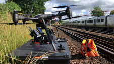
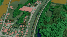
Plowman Craven has introduced Vogel Freedom, a UAV survey system designed for rail infrastructure surveying. Vogel Freedom is a survey-grade solution that surveys tracks without physical access. A novelty in...
Innovative methodologies based on artificial intelligence (AI) are lowering the barriers and democratizing the use of 3D digital twins in the geospatial industry. Digital twins are revolutionizing the geospatial industry,...
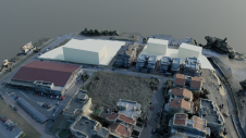
A team from Greece studied the use of aerial imagery to achieve wide coverage of a predefined geometrical area of interest in a project to explore the contribution of UAVs...
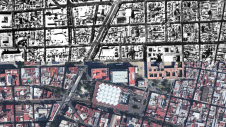
Over the past 15 years, geospatial information has enabled the transformation of towns, cities and a whole state in Mexico. The customer and data provider teamed up to create up-to-date...
This site uses cookies. By continuing to use this website, you agree to our Cookies Policy. Agree