COVID-19, the Land Administration Sector and Spatial Information
By now, most readers are likely to have been impacted by the COVID-19 pandemic – perhaps directly through their own health or the health of those they know, or more indirectly through loss of work or income… and almost certainly through the changes in social norms and freedoms brought about by various lockdowns. This article explores the relevance of the land administration sector, disaster risk management and spatial information in the context of the coronavirus outbreak.
It has been a busy few weeks due to the coronavirus outbreak. But, in the quieter moments (if we’re privileged enough to get them), we can reflect on what is happening now, what has happened and, probably most acutely, what might come next – in our personal lives, in our communities, in our daily work, and more globally.
On the surface, against the immediacy of rising death tolls, the shortages of ventilators and medical supplies, the nationwide lockdowns and the panic-buying of food, the land sector may seem very distant and perhaps even irrelevant. Digging a little deeper though, recent work on the relationship between land administration and disaster risk management actually seems pretty relevant to the situation.
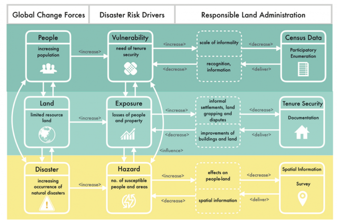
One recent study by the University of Twente [1] explored the relationship between land administration (LA) systems and disaster risk management (DRM). A key contribution was developing a shared language and conceptual model to help communication across those domains (Figure 1, [2]). Even though it was developed with natural disasters in mind, in the context of COVID-19, the different components and relationships start to light up. From the land sector perspective, we can make sense of why certain things happened, the current situation and perhaps what lies ahead.
Raising the Alarm
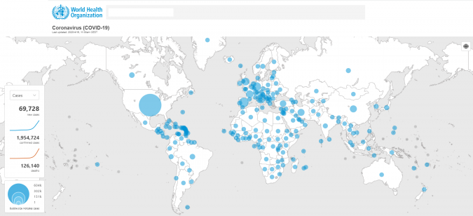
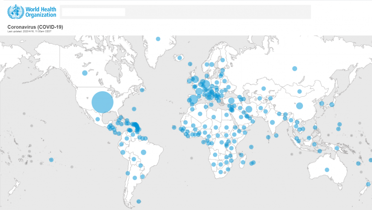
Let’s begin at the bottom of Figure 1, with the relationship ‘Disaster > Hazard > Spatial Information’. Apparently a chopping board, the mixed blood of a few exotic critters and a wet market in Wuhan, China, in December 2019 mark the ignition point of this biological disaster. In the space of a few days the hazard became provincial, if not country-wide, and shortly afterwards global. Following the chain, spatial information quickly became a resource of high importance in the effort to monitor and contain the virus. Similar to John Snow’s early paper-based spatial analysis of cholera cases in Soho, London, in 1854, maps plotting cases were quickly assembled and published, with daily updates – initially with coarse granularity at national levels (e.g. Johns Hopkins Institute) and then, as local responses became more coordinated, state and community breakdowns became available. The spatial visualizations and related graphs (i.e. curve flattening) made powerful impressions, and ultimately – although not immediately – helped to change the narrative of the virus spread. Rather than being just a side interest, this was an issue of central and immediate concern to all.

Tracking the Outbreak
By mid/late March 2020, with the outbreak declared a pandemic, tracking individual cases spatially, in terms of times and places of infection, was becoming a redundant exercise in many country contexts. Whilst several Asian countries appeared to have managed to control the spread, in most other countries the outbreak was still in its initial stages. The early containment successes in China, South Korea and Singapore were being much debated, with some studies suggesting mobile apps with associated positioning and monitoring abilities were key.
Enforcing Quarantine and Shutdowns
As the global death toll began to rise steeply in late March 2020, the seriousness of the outbreak began to take hold on governments and communities. This was especially the case for those countries outside Asia that had not experienced the impacts of the previous SARS and MERS outbreaks. Thanks to international air travel, the virus was already pervasive across many countries; community containment over outright prevention became the mantra. In an attempt to limit exposure (the ‘Hazard > Exposure’ phase in the model), social distancing and ‘staying at home’ became the new norm for many. Land-related information became central to control and to enforcing lockdowns and social distancing. In Italy, at the peak of the lockdown, people had to complete an online form and gain official permission in order to leave their homes. Address information was central in this approval and policing process. Land-use planning and zoning information became important; most business premises were told to close, and this also needed enforcement. In Israel, those infected had phone records interrogated to assess the places they had been and people with whom they may have come into contact, and also to ensure quarantine. In Austria, authorities used the positioning technologies in smartphones to check on whether individuals were following lockdown measures. Concerns about personal privacy and security received attention, but took a back seat to the greater community concern about virus containment.

Combating Tenure Insecurity
With country-wide shutdowns came the knock-on effect to the economy. The immediate impact was on public-facing service industries such as hospitality, retail and tourism. Within the space of two weeks, into early April 2020, claims for unemployment benefits in the USA alone jumped from the usually 200,000 cases to three million and subsequently beyond six million. The majority of these workers had either regular rental or mortgage payments to make. This is represented by the middle row of Figure 1: ‘Exposure > Vulnerability > Tenure Insecurity’. Many of those unemployed were facing eviction or mortgage default. This may be less of an issue in countries with strong rights for rental and lease holders. In other contexts, for example Australia and the Netherlands, sweeping anti-eviction laws were being passed in an effort to ensure people still had a place to stay during the lockdown. For mortgagors, financial institutions were offering six-month pauses on loan repayments. In the USA, as part of a trillion-dollar stimulus package, all government-backed mortgages were guaranteed. The link between the coronavirus outbreak and land administration was now stark. People had realized that it could result in widespread dispossession of housing and land, creating massive social upheaval, ultimately leading to informality and new slum formation.
Hibernating International Land Development
All the above happened in more developed country contexts with sound land markets, working land administrations systems and good land rights protection. But the contagion is only now entering the developing contexts, with less robust land sectors or no formal land market, and the potential impact and fallout there (the ‘Exposure > Vulnerability’ phase in the model) make for unpalatable contemplation. People living in conflict zones, refugee camps and informal settlements are amongst the poorest and most vulnerable: land is scarce and social distancing is not even possible. In those country contexts, many land agencies receive donor aid for the development and maintenance of land information systems. Those efforts and the related funding are now almost completely halted – due to international travel restrictions – and this means further impediments. The future of international development, and by association land sector development, is sure to be the subject of much analysis and discernment post-COVID-19.
Innovating in the Property Sector
Amongst all the concern and despair, one minor positive has been the swift innovation taking place across many sectors. Many employees have begun working fully from home. Technology has been at the forefront, with online meetings and virtual team environments quickly becoming the new working norm. In many countries even the land sector, traditionally conservative and slower to uptake technology opportunities, has seen a wave of radical changes in only a few weeks, or sometimes even days. This has included an increase in digital auctions, signing of virtual contracts, and virtual ‘open for inspections’ for both rental and buying markets. Innovation also enables cooperation between distant partners via start-ups such as in the case of Nepal. Many of these changes will be permanent and welcome.
Recovering via Land
Whilst predictions vary between weeks and years, there is agreement that the pandemic will end at some point – certainly with the development of a vaccine. However, even putting aside the immediate deaths and health impacts, the pandemic will leave in its wake a vastly different-looking social and economic landscape. Recovery will take years. Social impacts and scars will only be fully known later down the track. From a morbid perspective, isolating land for a massive number of potential burials and memorials may be needed in some contexts. Moreover, the high number of deaths, particularly amongst older generations, will bring forward much administration related to land inheritance and probate. Perhaps not unexpectedly, reports from China even indicate a pronounced spike in divorce requests and therefore splitting of assets, following lockdowns. Because these people/land issues often cut across agencies, systems are typically slower in dealing with these often-contested land transactions. In the short term, many systems may struggle to deal with the spike in transaction requests. Extra resourcing and fast-tracked procedures may need to be considered. Economic impacts and recovery will be more immediately measurable via land market metrics, land sector activities and the health of businesses operating within sector. The large stimulus packages being offered will take many years to pay off: the short-term stability for land use and land tenure will have a long-term economic cost.

Preparing and Future Planning
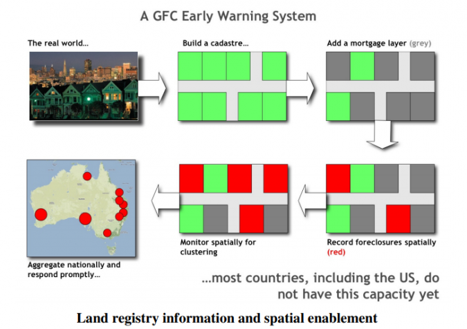
Beyond recovery, attention will turn to future preparedness. For the land sector, this will involve: i) assessing the effectiveness of spatial information flows in contributing to early-warning and monitoring systems (e.g. tracking apps), whether there were bottlenecks, whether non-traditional land data sources might have helped the cause, and whether lack of international integration in land information systems impeded efforts; ii) examining the effectiveness of measures used to secure rental and property markets on a massive scale and to maintain land values, and revisiting the concept of the defaulting land market early-warning system; iii) determining whether land use and spatial planning contributed to the creation of the virus (e.g. animal stress), its more rapid spread in some cities (e.g. compact cities), and how to contain and control ignition points (e.g. wet markets) in terms of land development, spatial planning and land use planning; and iv) critically assessing whether existing land administration systems are adequately equipped to protect, prepare and mitigate biological disaster impacts.
Summary and Outlook
The 2020 COVID-19 pandemic is unparalleled in terms of its scale and impact. It is too soon to fully understand its origins and future consequences. All livelihoods and sectors are in some way impacted. For the land sector, the outbreak again brings to light the very intimate relationship between land and disaster. The sector may have had a role in the creation of the pandemic, certainly underpinned tracing and containment efforts, and is likely to feel the brunt of future economic fallout through land market decline (or collapse) and subsequent tenure insecurity. The land sector can learn lessons from all this, but, in the immediate term, its actors should do what others are doing: help impede the spread of the virus and assist those in need in a responsible way – and in particular those working in the health sector, currently at the forefront.
[1] The work, led by Dr. Eva Maria Unger, formed part of a PhD thesis, successfully defended in September 2019. It was supported by Kadaster International and was supervised by Prof Jaap Zevenbergen, Prof Chrit Lemmen and Dr Rohan Bennett.
[2] See: Unger, E. M., Zevenbergen, J., & Bennett, R. (2017). On the need for pro-poor land administration in disaster risk management. Survey Review, 49(357), 437-448.

Value staying current with geomatics?
Stay on the map with our expertly curated newsletters.
We provide educational insights, industry updates, and inspiring stories to help you learn, grow, and reach your full potential in your field. Don't miss out - subscribe today and ensure you're always informed, educated, and inspired.
Choose your newsletter(s)


