Digitalization in the construction industry
Opportunities and threats for the geospatial sector
Besides the surveying hardware & software and the intricacies of BIM and data exchange, this article explores broader aspects of digitalization in the construction industry. How are they affecting the geospatial sector? What are the opportunities and threats? What about the human factors? And how is the geospatial data actually used in practice?
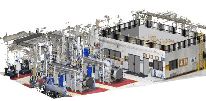
Whether on brownfield or greenfield sites, most construction projects start with a site survey. This can be done using conventional surveying equipment or with modern tools such as unmanned aerial vehicles (UAVs or ‘drones’) for photogrammetry and laser scanners for mapping. Surveyors can then support the project by monitoring progress, measuring spoil heaps and excavations, and eventually doing a full as-built survey using mobile and terrestrial mapping equipment which produces both a point cloud and panoramic photographs. All these efforts contribute to deliverables such as the Common Data Environment (CDE), building information modelling (BIM) datasets and digital twins.
Accurate point clouds, models and imagery produced by surveyors can reduce the need for others to visit the site. This can save time and reduce the carbon footprint due to transport. Easily available reality capture data will also encourage project team members to check details more frequently, which can save time during the design process and reduce mistakes. Finally, minimizing the number of people on site is obviously an advantage during the ongoing pandemic. In line with this, it is beneficial for surveying professionals to become more familiar with BIM and how it is used in the construction industry – not only in order to do their own work more effectively, but also to best understand and support their customers.

BIM in theory and practice
One important consideration is that not all clients may be fully familiar with BIM, especially if it has been imposed on them by their own customers. For example, some people may think that BIM and the Revit model are one and the same, rather than realizing that Revit is a tool that relates to BIM. As a surveyor, it pays to take the time to explain that BIM is not Revit, how BIM fits into the client’s business, and how you can support them with activities and advice to implement BIM effectively. You may have to emphasize that the ‘M’ in BIM stands for ‘modelling’ rather than ‘model’. In other words, it is not a single 3D model, but a continuous process to ensure effective exchange and management of information covering the whole lifecycle of the structure.
However, BIM is not a panacea. Smaller construction businesses may simply be overwhelmed by BIM and everything it entails. They may not have the financial or human resources to adopt it – yet many construction projects depend on such contractors. Clients may also be sceptical, or feel that BIM is not relevant to their property portfolio. A surveyor with a large UK housing association commented: “I haven’t seen BIM in a live environment. It’s a fantastic concept, but none of the developments I’ve been involved with could justify the cost. Maybe in a few more decades it might become commonplace.” Nevertheless, BIM is already widely adopted in other parts of the construction industry.
Focusing on client needs
As geomatics professionals we only produce data because our clients need it. That means we have to focus on how our GIS data interfaces to the BIM systems of our clients (see also a previous article in GIM International, ‘Bridging the Gap between Geospatial and Construction’). This can be a challenge because geospatial data usually refers to points, while BIM data refers to objects. Therefore, it is important to be aware of the needs of each client and how far advanced they are in terms of BIM and other aspects of digitalization.
People and organizations
The fact that digitalization and, specifically, BIM are processes rather than technical products means that everything revolves around people and the organizations they work in. Dealing with those aspects can be a challenging experience for a surveyor who is more used to working with hardware such as total stations than with the human aspect. A report by McKinsey called ‘Culture for a digital age’ identified cultural and behavioural challenges as the key obstacles to meeting digital priorities. It also suggested that cultural changes are slower and more complex than the changes in technology which drive them. This is likely to apply both to geomatics businesses and their customers, and to digitalization in the construction industry in general. The changes associated with digitalization will be particularly challenging for smaller and more traditional construction businesses.
In the context of gauging BIM maturity, David Shepherd (BIM leader at the UK House of Commons project) has written about the need to focus on collaboration between people and businesses, and not solely on prescriptive processes. He is concerned that overly prescriptive processes can discourage creativity, as a result of which BIM would harm rather than enhance the project outcome. He calls for team leadership and shared values to ensure that data and digital technology benefit the deliverables. He also feels that software vendors should price their products such that they are accessible to small and medium-sized businesses. Those observations are likely to be relevant to other aspects of digitalization in the construction industry too.
Potential threats
Geomatics professionals need to be aware of technical developments which can reduce the need for specialist surveyors. For example, modern earthmoving equipment fitted with GNSS and a range of sensors can be controlled directly from the construction designs. This can not only avoid costly overdigging or underdigging, but can also reduce the need for regular surveys of the excavation. Some handheld laser scanners are now affordable enough that even smaller construction companies can buy them. Photogrammetry can now be done using a drone or smartphone and affordable (or even free) software.
These aspects of digitalization mean that surveyors need to convince clients that they are still relevant because of the assured quality of their work or more efficient workflow, and independence. So how can you prove that? It may help if you explain that an apparently cheap survey could turn out to be very expensive in the long run if it leads to problems during the construction project. Even so, some surveying markets may be eroded. This is all the more reason for the geomatics community to monitor and anticipate developments in the market, and aim to develop new applications and markets.
Modern methods of construction
In many construction-related markets, the need for greater efficiency and the shortage of skilled labour are leading to various degrees of prefabrication or off-site construction. This will encourage further digitalization and is likely to have an impact on the demand for geospatial services.
Projects to refurbish or extend existing buildings, especially older ones, frequently rely on traditional, on-site construction. This is because the geometry is often complex and irregular. Consequently, new components are cut and offered up to the existing structure on site to ensure a good fit. In some cases, laser scanning can now be used to scan the site to a high degree of accuracy. This can enable off-site fabrication of components such as cross-laminated timber panels and piping assemblies. Such digitalization developments can increase efficiency and save the time spent both on site and travelling to sites by construction workers. Similarly, detailed laser scans with panoramic photographs make it much easier to check even small details during the design process. This can help architects, consultants and designers to do their work more efficiently, and avoid clashes and problems which need to be resolved on site during the construction process.

Digitalization and muddy boots
The mining industry has already implemented a number of digitalization projects using autonomous or remotely controlled equipment. This is sometimes combined with full or partial electrification of the equipment to reduce greenhouse gas emissions. Digital advancements are continuing to enable the introduction of a range of innovative equipment on construction and civil engineering sites.
Existing digitalization of construction and civil engineering equipment ranges from fully autonomous robots through to seemingly conventional construction plant fitted with a range of digital systems to assist the human operator. UAVs are already widely used for regular site surveys to monitor progress. Technological solutions such as augmented reality (AR) and virtual reality (VR) are currently being used in construction. The applications include remote site visits and inspections, training, presentations, etc. Geospatial applications include displaying previously gathered information while undertaking a site survey. Trimble SiteVision, Topcon MAGNET and Leica Captivate are examples of this.
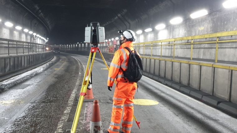
Digital twins based on laser scans or photogrammetry are already proving very useful for the maintenance of existing assets. For example, public housing providers in Sweden and the Netherlands have used UAS photogrammetry to inspect thousands of properties, as covered in earlier articles in GIM International. In the Netherlands, Rijkswaterstaat has commissioned digital twins (based on laser scans, combined with photographs) of eight tunnels to be refurbished. The first one immediately proved its value when the COVID-19 epidemic started; the tender for the refurbishment could be continued by giving the bidders access to the digital twin instead of organizing site visits.
In another example, the HS2 railway project in the UK is planning to use VR, BIM and a digital twin to optimize future maintenance. This will include live data from thousands of trackside and on-train sensors which is sent to the Network Integrated Control Centre. Before going out on site, engineers will use VR headsets to investigate issues from the control centre. This will help them prepare the maintenance operations more effectively and resolve issues remotely where possible.

Future outlook
This article has shown that the opportunities for the geospatial sector related to digitalization in the construction industry outweigh any threats it may pose. Moreover, by focusing on the needs of their clients and educating them on the benefits of BIM and other digitally enabled technologies, surveyors can help their clients to improve the quality of their work while saving time and money. As a result, surveyors can reinforce their relevance and cement their existing client relationships, plus also branch out into new applications and markets for an even brighter future.
Three innovative digital solutions for construction sites
Robot Plotter
The Tyker company, a spin-off of Wageningen University in the Netherlands, has developed the Robot Plotter. This small autonomous vehicle to apply surface markings was originally developed for road paving applications, but is now finding broader use such as in setting out foundation engineering projects. The unit navigates using GNSS-RTK outdoors and can be controlled by a total station in areas of poor GNSS reception, such as inside buildings.
Robotic laser scanning dog
Trimble has mounted one of its X7 laser scanners on the Spot robotic dog produced by Boston Dynamics. This works with the company’s FieldLink construction layout and scanning software and is intended for work progress monitoring. Spot can negotiate obstacles and even stairs, which makes it perfect for deployment on construction sites. After completing a scanning assignment, the unit returns to its docking station which not only recharges the batteries of the scanner and the robot, but also transfers the geospatial data back to the office.
Smart Construction project
Earthmoving equipment manufacturer Komatsu has developed a digital workflow solution for the full construction process, from bidding to the final handover and reporting. Smart Construction is an open project with over 20 partners. It includes design software, machine sensors, fleet management and survey tools. Smart Construction applications can upload 3D models to earthmoving equipment such as excavators and bulldozers. Automatic machine control then ensures that the right contours are followed during the operations. Sensors on the machines automatically provide as-dug data. This reduces the need for minor survey operations, although major works still need to be followed up by a verification survey. Richard Clement of Komatsu Europe comments: “Technology will help us turn construction sites into better, safer and more up-to-date workplaces. This is especially important for the future of our industry, with many companies struggling to attract both young and skilled people.”

Value staying current with geomatics?
Stay on the map with our expertly curated newsletters.
We provide educational insights, industry updates, and inspiring stories to help you learn, grow, and reach your full potential in your field. Don't miss out - subscribe today and ensure you're always informed, educated, and inspired.
Choose your newsletter(s)


