Leica Geosystems’ New 3D Imaging Laser Scanner Available in Europe
Leica Geosystems has announced that its BLK360 miniaturised 3D imaging laser scanner is now available for reservation within Europe, for delivery in summer. The laser scanner simplifies the collection of as-built reality capture data for work in architecture, design, construction and engineering, among other vertical markets.
If you have ever relied on pencil and paper, tape measures, or other laser measuring devices to capture a room’s dimensions and images, you know that there is always redundancy and missed measurements, said Steven Gross, architectural engineer, Valley Home Improvement. With the BLK360 those issues disappear. Everything is captured on the first visit, which streamlines the process, saving enormous amounts of time. Not to mention that it makes you look that much more professional to your clients.
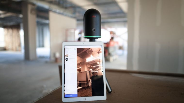
Spherical image and laser scan
Users simply place the lightweight BLK360 on a level surface or tripod and, with the push of a single button, it captures 360º HDR spherical imagery and takes a 360,000 point per second laser scan. Getting measurements right the first time, the BLK360 features +-4mm accuracy at 10 metres and an overall 0.6 - 60 metre range. Within three minutes, the spherical image and laser scan is completed and ready to view in the Autodesk ReCap Pro for mobile app, which runs on an iPad Pro. From there, users can take measurements, add markup and annotations or share onsite data with their colleagues back in the office.
The BLK360 brings together exclusive technologies to deliver outstanding performance, all while simplifying the process of 3D image scanning and reality capture through the touch of a single button, said Burkhard Böckem, CTO, Leica Geosystems. This has enabled them to create new opportunities for scanning experts and introduce entirely new audiences to laser scanning while uncovering possibilities that were previously unimaginable.
The BLK360 has already earned several prestigious industry awards including the PRISM Award for Photonics, iF Design Award, the Red Dot Design Award, and the Geospatial World Innovation Award, and was also a CES Innovation Award nominee.

Value staying current with geomatics?
Stay on the map with our expertly curated newsletters.
We provide educational insights, industry updates, and inspiring stories to help you learn, grow, and reach your full potential in your field. Don't miss out - subscribe today and ensure you're always informed, educated, and inspired.
Choose your newsletter(s)


