Customary Cadastres and Smartphone Surveys
Fitting with the Local Needs
The complex nature of customary land administration, coupled with slow, expensive and highly centralised national land registration systems, means the registration of customary land rights is oft neglected. Estimates suggest a mere 0.5% of Ghanaian customary land holdings are registered, making land grabbing in peri-urban areas easier and land management activities, such as land consolidation, highly impeded. Read on for an article showing the results of an experiment in which a smartphone app was used to enable a participatory, faster, cheaper and a more fit-for-purpose approach to rural customary land administration.
(By Kwabena Asiama, Rohan Bennett and Jaap Zevenbergen, University of Twente, ITC)
Ghana’s customary lands account for 80% of the country’s land parcels. They are usually managed by what are known as ‘Traditional Authorities’ (TAs). The majority of these TAs have successfully set up Customary Land Secretariats (CLSs) to manage land on their behalf. However, the rural CLSs have limited capacity to map land parcels. The costs of land surveys are high (not less than EUR500 per parcel for the complete process) and the surveyors themselves prefer to focus on more lucrative urban land mapping. The prevailing situation has resulted in CLSs seeking alternative ways to build up an appropriate land administration system (LAS).
As in other countries such as Kenya and Ethiopia, the use of orthophotos has been shown to be successful in mapping the urban areas of Ghana; visible boundary markers and fence walls mean the mapping process does not necessarily require excessive numbers of highly trained surveyors. In rural areas, however, general boundaries and temporary boundary markers are difficult to discern so there is a need for alternative ground survey methods – ones that are not as costly as conventional surveys based on total stations, chains/theodolites or high-precision GNSS. Promisingly, the registration laws of Ghana do provide for the use of general boundaries for first registration. Fixed boundaries are only necessary for subsequent registration and transactions, which opens up an opportunity for CLSs.
Fit-for-purpose Land Administration
Fit-for-purpose land administration is about building sustainable systems – within appropriate time frames, at minimal cost and at the required accuracy – that record a diversity of land rights. Smartphone usage is widespread in Africa, with a used Samsung Galaxy S2 (3G-enabled device) costing EUR25 in Ghana). As shown in articles in previous editions of GIM International (see ‘Further reading’), this provides an opportunity for land administration: fusing the phone’s GNSS functionality with a mapping app – and available imagery – creates a low-cost surveyor’s toolkit. Esri’s Collector for ArcGIS is freely downloadable (albeit with a subscription), providing a friendly environment for the geotech savvy. In addition, freely available satellite imagery from Esri can be loaded in advance. The app allows for the recording of the land rights information in tandem with the collection of the spatial information, allowing for ease of information management.
Living the Experiment
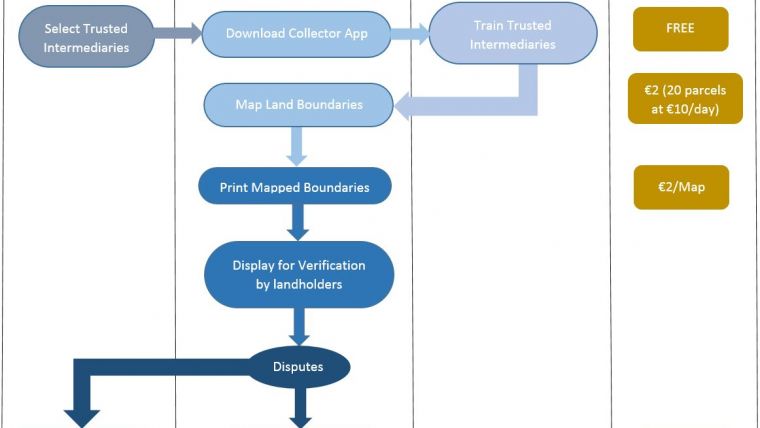
In the Northern Region of Ghana, in a place called Nanton, there is a real need to record information about land holdings. The need is driven by ideas to consolidate smaller land holdings into larger ones, and subsequently to improve agricultural output. With this in mind, in collaboration with the local TA, a test of a fit-for-purpose mapping approach using smartphones was set up by researchers from the University of Twente, ITC in a responsible ‘living lab’-style arrangement in July 2016. For the TA, the aim was to obtain information about land holdings, whilst the research team sought to help the process, as well as to replicate and test the claims already made by Dyli, et al. (2016) in Ethiopia and Molendijk et al. (2015) in Columbia. Community involvement was paramount; the TA in the area was informed prior to the exercise and assisted in the site selection. Also with the help of the TA, two trusted intermediaries – staff of the CLS – were selected and trained in the use of the app.
A Worldview-1 satellite image of the area from February 2016 was also acquired from DigitalGlobe Foundation and was printed out to be used for visual support for, and validation of, the data collected using the ground methods. The stream feature of the Collector app was used to enable the data to be collected automatically as the trusted intermediaries walked the perimeter with the farmers. This was done for each parcel within the area of interest. At the end of the ten-day experiment, 200 farm parcel boundaries had been mapped and verified by the team.
Results and Reaction
The involvement of the community is paramount to the adoption of new technology, to allow for its use without the involvement of the researcher – or a fully licensed surveyor. The approach used in this experiment was a hands-off one; the farmers and the trusted intermediaries undertook the mapping on their own. The CLS staff and the farmers found the app to be very user friendly and the TA showed interest in adopting it to supplement its land administration system (which currently comprises land-rights information but no spatial information).
Given the slow and expensive conventional land survey methods, the TA regards this process as offering an alternative way for its CLS to secure the land rights. This approach is comparatively faster at an estimated EUR9 per parcel and is flexible enough to incorporate the different levels of customary land rights. On the part of the farmers, it also serves as a check of the size of their farms to determine the quality of inputs ideally needed. The information is stored in the cloud and updates can be effected by the farmers themselves, with the approval of the CLS.
Concluding Remarks
This app shows much promise as it will serve as an initial step towards a faster, cheaper and trustworthy approach to registration of the rural customary lands. The use of smartphones, which are widely available in Africa, provides a unique opportunity as a fit-for-purpose process is possible without the need for a CLS to acquire extra equipment. Furthermore, while the approach used by conventional surveyors only registers the coordinates of the corners of land boundaries, this approach is suitable for mapping irregularly shaped farmlands.
Further Reading
Dyli, J., Bennett, R. M., & Martinez, J. A. (2016, August). Apps for Land Administration: Exploring the Needs, Options and Future Developments. GIM International, 33–35. Retrieved from https://www.gim-international.com/magazine/august-2016
Lemmen, C., Bennett, R., McLaren, R., & Enemark, S. (2015, January). A New Era in Land Administration Emerges. GIM International. Retrieved from https://www.gim-international.com/content/article/a-new-era-in-land-administration-emerges
Molendijk, M., Morales, J., & Lemmen, C. (2015). Light Mobile Collection Tools for Land Administration. GIM International. Retrieved from http://www.gim-international.com/content/article/light-mobile-collection-tools-for-land-administration
Acknowledgement
The authors wish to thank DigitalGlobe Foundation for their support.
Biographical Data
Kwabena Asiama is a PhD candidate at the University of Twente, Faculty of Geo-Information Science and Earth Observation (ITC) in Enschede, The Netherlands.
Rohan Bennett is an associate professor at the University of Twente, Faculty of Geo-Information Science and Earth Observation (ITC) in Enschede, The Netherlands.
Jaap Zevenbergen is a professor of land administration and management at the University of Twente, Faculty of Geo-Information Science and Earth Observation (ITC) in Enschede, The Netherlands.
Figure Captions
Figure 1, The mapping process and the costs incurred.
Figure 2, Farmers and a trusted intermediary (holding the smartphone) are happy with the results.
Figure 3, The mobile app interface.
Figure 4, Identification of the farmlands on the satellite image.

Value staying current with geomatics?
Stay on the map with our expertly curated newsletters.
We provide educational insights, industry updates, and inspiring stories to help you learn, grow, and reach your full potential in your field. Don't miss out - subscribe today and ensure you're always informed, educated, and inspired.
Choose your newsletter(s)


