VisionMap Releases LightSpeed Version 3.7
VisionMap, a leading provider of aerial survey and mapping systems, has released a new version of its A3 LightSpeed image processing suite. The new version includes several upgrades and new features. The software’s orthophoto radiometry has been further improved through the implementation of a new and improved algorithm for haze reduction.
LightSpeed’s DataViewer user interface has been enhanced to create a user experience especially suited for large-scale projects, such as those acquired by the A3 Edge Digital Mapping System. A new feature was implemented enabling users to easily merge multiple acquired sessions into a single project, streamlining management of the entire project.
Additional enhancements include the addition of export customization options, and instant loading of images when opened. Finally, users can now export stereo models in 4-band or false color, in addition to RGB or NIR.
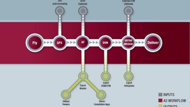
A3 Lightspeed processing system is a photogrammetric workflow that automatically processes hundreds to thousands of km2 of A3 camera imagery per day for various mapping applications. The system is also designed to support rapid response applications since it is capable of providing accurate products within a short time line without relying on DGPS stations, ground control points or existing DEM. LightSpeed end-to-end workflow produces aerial triangulation, DSM, orthophoto, stereo models, photogrammetric oblique imagery.
The image shows the A3 LightSpeed workflow (courtesy: VisionMap).

Value staying current with geomatics?
Stay on the map with our expertly curated newsletters.
We provide educational insights, industry updates, and inspiring stories to help you learn, grow, and reach your full potential in your field. Don't miss out - subscribe today and ensure you're always informed, educated, and inspired.
Choose your newsletter(s)


