Geospatial Data as a Vital Tool for Protecting Planet Earth
This specially selected series of articles illustrates how geomatics plays a key role in protecting and preserving the environment. Geospatial data forms an important part of the toolkit of researchers and other experts involved in nature conservation. Check out these examples of how geomatics techniques have been applied in practice around the world.
Creating a Digital Twin of the Earth
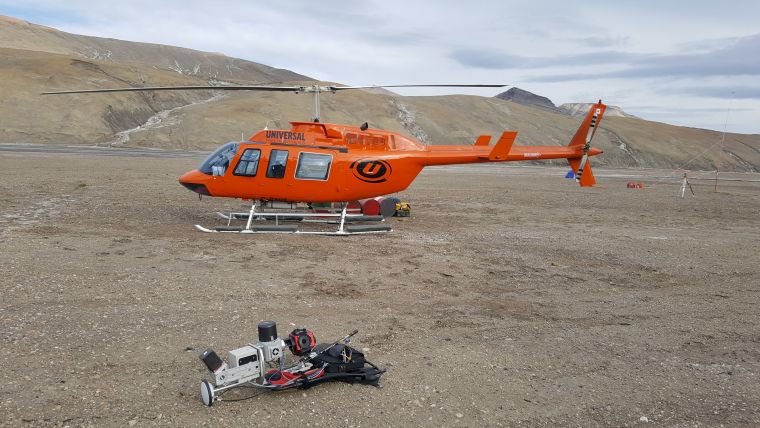
An unprecedented scientific effort to Lidar-scan the entire surface of the Earth before it’s too late... that’s how Christopher Fisher, the founder of the Earth Archive, describes his initiative. He started the Earth Archive based on his experience of using remote sensing technologies in Mexico and Honduras. His aim is to better understand the causes and consequences of urbanism and environmental change.
How Geospatial AI Leads to Smart Urban Ecosystems
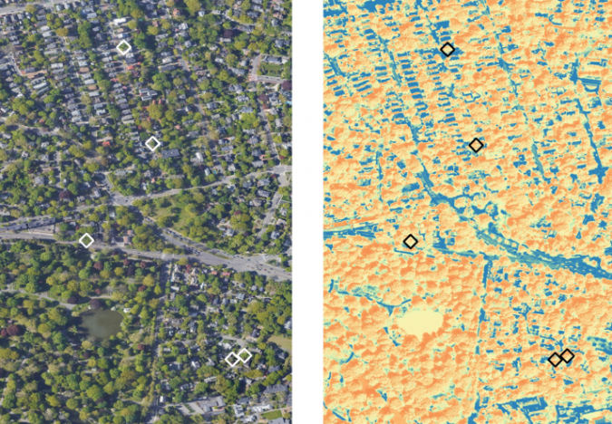
The use of satellite imagery to manage the health of trees in cities improves urban ecosystems. By combining traditional methods with other geospatial technologies, such as remote sensing, and artificial intelligence to achieve ‘geoAI’, it is possible to detect and classify features even faster and more accurately. GIM International spoke to Dr Nadina Galle, an award-winning ecological engineer and entrepreneur dedicated to applying emerging technologies, to learn more about the seemingly limitless possibilities of geoAI
Upscaling of Terrestrial Laser Scanning through Fusion with Remote Sensing Data
3D information on the Earth’s forest ecosystems is essential to support long-term carbon monitoring, especially now that the world’s climate is indisputably under pressure. Terrestrial laser scanning is increasingly being fused with air/spaceborne Lidar to characterize vegetation structure across a range of forest ecosystems. This article explores the potential of this approach to support scaling up for larger areas in practice.
Finnish Geospatial Research Institute Expands Airborne Toolbox
The Finnish Geospatial Research Institute (FGI) has recently added the RIEGL VQ-840-G airborne laser scanner to its impressive collection of sensors. FGI innovators are true scientists, moving the 3D industry forward in new ways that will prove very interesting to watch. The new low-altitude bathymetry sensor will be employed for surveys in areas of shallow water such as wetlands, riverbeds and coastal areas.
Changed Perspectives in Land and Water Management
Situated in the delta of the rivers Meuse and Rhine, the Netherlands have a long tradition in land and water management. The fertile soils along the rivers and coast were quickly occupied for food production, the waterbodies were used for transportation of people and goods, and along this transportation network settlements emerged. However, the proximity to water bodies also meant the risk of flooding. Since the very first beginning, the main aim was to reduce the risk of flooding by embanking the rivers. Dams and locks were constructed as well to keep water levels high enough for – cross border – traffic on the rivers further inland.

Value staying current with geomatics?
Stay on the map with our expertly curated newsletters.
We provide educational insights, industry updates, and inspiring stories to help you learn, grow, and reach your full potential in your field. Don't miss out - subscribe today and ensure you're always informed, educated, and inspired.
Choose your newsletter(s)


