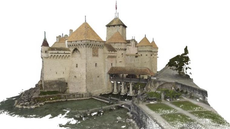
High-precision 3D Modelling of Historic Monument in Switzerland
Pix4D has created a highly accurate and very dense 3D model of Chillon Castle (Château de Chillon), Switzerland’s most visited historic monument. The 3D point cloud integrates the indoor and outdoor structures of this highly complex architectural object with a resolution of up to 5mm. It is based on both aerial and terrestrial images captured using DJI Phantom 2 Vision, GoPro Hero 3+, Canon 6D and Sony alpha 7r cameras with fisheye lenses.
Chillon Castle is an island castle located on the shore of Lake Geneva, next to the city of Montreux. It is a highly interesting structure for photogrammetry and 3D modelling as it consists of over 21 independent buildings that were gradually connected between the 11th and 13th century. Today, the castle is one of Switzerland’s most famous landmarks and is visited daily by thousands of visitors from around the world.
Datasets
To create the 3D model, over 6,200 images have been acquired during one morning in 4 hours by a team of 7 people. A complete dataset of the castle has been acquired from the air using a DJI Phantom2 Vision and its integrated camera with a fisheye lens at a resolution of 14MP. Another complete dataset was done using the GoPro Hero 3+ at a resolution of 12MP, mounted on a custom quadrocopter for the aerial imagery and held by hand for the ground imagery, walking around the castle for the parts that are accessible on foot and boating the parts only accessible by water.
For the inside structures – inside courtyards as well as 18 rooms – a Canon 6D (20.2MP full frame CMOS sensor) with a 8mm fisheye lens and a Sony alpha 7r with an 8mm Rikonon fisheye lens (capturing APS-C size images with 4800x3200 pixels) were used with an image taken approximately every metre. Additional imagery from parts of the outside structure was also acquired with these two cameras. To georeference the model and achieve the best possible accuracy, a total of 9 GCPs (Ground Control Points) were distributed over the site.
In total, the data acquisition was divided into 19 datasets that were processed individually using the automatic workflow of Pix4Dmapper. Each sub project was geo-referenced with the same GCPs to ensure the accuracy. For each step of the merging process, a separate bundle adjustment was performed using Pix4Dmapper’s integrated rayCloud Editor. The sub projects were then merged into larger projects until all images have been combined into one final model made up of 95 million points. The accuracy of the model varies between 5mm and 20cm, depending on the camera as well as the GSD the images have been acquired with.
Purely image-based
The highly accurate 3D inside and outside reconstruction of such a geometrically complex structure shows the potential of purely image-based 3D reconstruction for applications such as cultural heritage, archaeology and architecture. It demonstrates the possibility of using both ground and aerial imagery acquired at nadir and oblique angles in the same project, opening up countless new applications using affordable and easily available sensors like the GoPro or DSLR cameras.
The data acquisition as well as the final results can be viewed in the video of this project.
To view the 3D model and download the White Paper on this project, see www.pix4d.com/chillon.

Value staying current with geomatics?
Stay on the map with our expertly curated newsletters.
We provide educational insights, industry updates, and inspiring stories to help you learn, grow, and reach your full potential in your field. Don't miss out - subscribe today and ensure you're always informed, educated, and inspired.
Choose your newsletter(s)


