Intelligent Robot for Mapping Applications in 3D
Motivated by the increasing need for rapid characterisation of environments in 3D, a German university has designed a robot system that automates the work of an operator of terrestrial laser scanners. The system makes it possible to work without markers or targets, saving surveyors more than 75% of the time spent on site. Another impulse for developing the platform was the demand for a remote inspection tool.
The robot is capable of surveying remote sites or danger areas, such as plants, underground mines, tunnels, caves or channels. The availability of the robotic platform further enables the study of mobile laser scanning systems. Now, the system is ready to do the work. This article details firstly the mobile robot and secondly the software solution. The software consists of automatic, high-precision registration programmes for terrestrial scans, i.e. bundle adjustment, and extension to mobile mapping, which requires precise calibration and trajectory optimisation. The algorithms do not rely on features at any point.
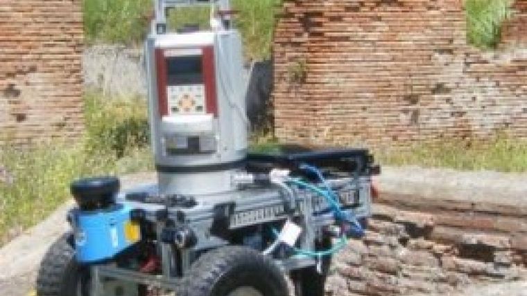
The Intelligent Robot for Mapping Applications in 3D (Irma3D) is a robotic mobile laser scanning system for automating terrestrial laser scanning and miniaturising mobile mapping. Scientific issues like automatic registration and calibration in a mobile laser scanning scenario have been explored. Irma3D is a small, lightweight, battery-powered, three-wheeled vehicle.
With a width of 52cm and an overall length of 65cm it is small enough to pass through narrow doorways. The three-wheeled design allows for a high manoeuvrability such that it can rotate on the spot. These properties make Irma3D ideally suited for indoor environments. However, the high-powered electrical two-active-wheel differential drive with a top speed of about 2.2m/s combined with the passive castor also make it capable of operating in moderately challenging outdoor environments. The robot is controlled remotely, either via a WLAN connection or through a gamepad. Irma3D can also be used in a fully autonomous mode. Once activated, Irma3D will attempt to explore its surroundings within preset limits and create a 3D map of the environment.
Read the article 'Towards Optimal 3D Point Clouds' by Andreas Nüchter, Jan Elseberg and Dorit Borrmann here.
Further Information
Several programmes for processing terrestrial laser scans are available under GNU public licence within the ‘3DTK – The 3D Toolkit’ project at sourceforge (http://threedtk.de).
For a comparison between a state-of-the-art mobile mapping solution with an Optech scanner and the semi-rigid SLAM: http://youtu.be/L28C2YmUPWA. For more videos and animations of the robot: http://www.youtube.com/user/AutomationAtJacobs.
For further information about the scanners: www.riegl.com and www.youtube.com/user/RIEGLLMS.

Value staying current with geomatics?
Stay on the map with our expertly curated newsletters.
We provide educational insights, industry updates, and inspiring stories to help you learn, grow, and reach your full potential in your field. Don't miss out - subscribe today and ensure you're always informed, educated, and inspired.
Choose your newsletter(s)


