Leica Geosystems Launches New Mobile Mapping System
Leica Geosystems has launched a reality capture mobile mapping system called Leica Pegasus TRK, introducing artificial intelligence, autonomous workflows and intuitive interfaces.
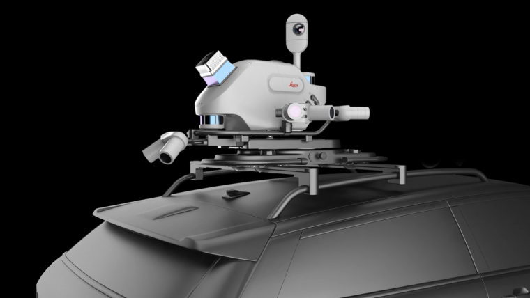
The Leica Pegasus TRK solution utilizes artificial intelligence capabilities to transform mobile mapping. The advanced dynamic laser scanning and expandible imagery system for recording, measuring and visualizing environments increases productivity with automated, intelligent workflows.
Suitable for Non-geospatial Professionals
Due to its low weight, the Pegasus TRK can easily be operated by one person, making mapping projects more efficient and cost-effective. Because of the system’s user-friendliness, it is suitable for professionals who are new to the technology. At the same time, its reliable, high-quality deliverables serve the needs of technical experts in various industries, including surveying, transportation, and utilities. The Pegasus TRK solution features an AI-enhanced camera and automatic camera calibration. To comply with privacy regulations, its artificial intelligence (AI) can identify and blur identifiers, such as people and vehicles, in real time.
The Pegasus TRK solution enables long-range mobile mapping for applications in asset management, road construction, rail and critical infrastructure, oil, gas and electricity industries, and more. The system is also very suitable for creating high-definition base maps for autonomous vehicles.
Post-processing Workflows
The Pegasus TRK connects with the new Leica Pegasus FIELD software for fully autonomous and secure data collection and route planning in the field. It also connects with the Leica Cyclone Pegasus OFFICE for seamless input into post-processing and publishing workflows.
“The Pegasus TRK solution is the most efficient mobile mapping product we’ve tried so far,” said Raymon Somford, CEO and owner of Rise3D. “It is lightweight and easy to use, guiding our team through the process of data collection. Its sensors that trigger automatically avoid missing details. We can achieve quality images regardless of the conditions, making mobile mapping almost effortless.”
“The Pegasus TRK solution offers flexibility, true-to-life image clarity and best-in-class accuracy while making mobile mapping more accessible and easier than ever before,” commented Christian Schäfer, business director mobile mapping at Leica Geosystems. “There is a growing demand for more autonomy. This solution raises the bar in data collection with automated route-planning, guidance and collection processes that increase efficiency, improve data quality and reduce project costs.”


Value staying current with geomatics?
Stay on the map with our expertly curated newsletters.
We provide educational insights, industry updates, and inspiring stories to help you learn, grow, and reach your full potential in your field. Don't miss out - subscribe today and ensure you're always informed, educated, and inspired.
Choose your newsletter(s)


