Measuring a Zero-gravity Plane with a UAV
Surveyors Uli Bauer and Andreas Gelhausen have generated a 3D model of the landing gear of the zero-gravity Airbus A300 ZERO-G – used to perform parabola flights for scientific purposes – that is accurate to +/-5mm. Furthermore, they have used the Aibot X6 UAV to generate a point cloud of the aircraft.
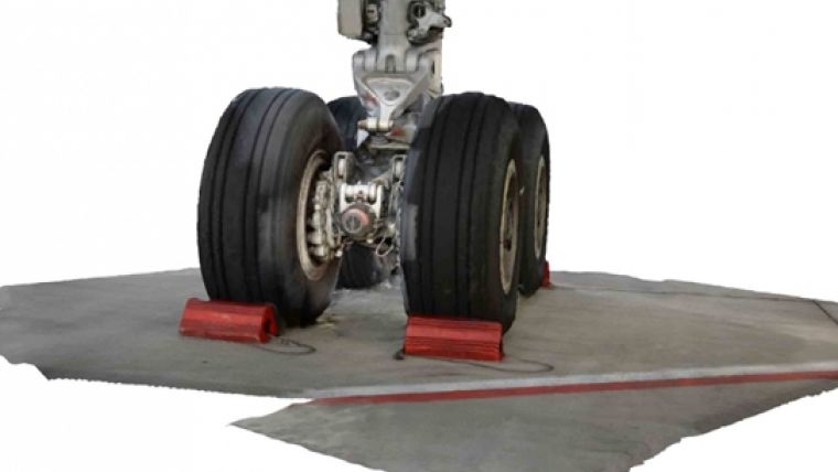
After the 25th research campaign of the German Aerospace Center (DLR), the Airbus A300 ZERO-G from the French company Novespace is due to be retired. The aircraft, which has been used for 15 years by DLR for scientific research into microgravity, is to be put on display at Cologne / Bonn Airport for visitors to look around. For this reason, a supporting construction is needed for the aircraft to stand on permanently without its tires touching the floor.
Photogrammetry and laser scanning
The landing gear only has five position points, known as pins, which the aircraft can rest upon. The surveyors were tasked with determining the position of the pins geometrically. Since Bauer and Gelhausen wanted to use photogrammetry to generate the data, they first scanned the landing gear with a Leica Scan Station C 10 to use as a reference. Following this, Gelhausen photographed the landing gear from all angles with a Nikon Coolpix A to create a 3D model from the pictures. At the relevant points, the model has an accuracy of more than +/- 5 mm. Working with photogrammetry for the very first time on this type of task, the surveyor was very impressed by its accuracy.
The final image analysis is very detailed and accurate, the results are amazing. The comparison with the laser scanned data has shown that it is possible use the Hexacopter Aibot X6 system readily for such tasks in the future, Gelhausen commented.
In order to capture the aircraft in its entirety, so as to quickly determine the dimensions for future transportation and final positioning, the surveyors covered the Airbus with the Aibot X6 UAV. They used a digital camera to generate data, which was further processed to produce a point cloud. Using the Hexacopter means the measurements can be carried out much faster than with conventional methods, but the accuracy remains the same, Gelhausen said.
Interested to learn more about the Aibot X6 UAV? Go to Geo-matching.com.

Value staying current with geomatics?
Stay on the map with our expertly curated newsletters.
We provide educational insights, industry updates, and inspiring stories to help you learn, grow, and reach your full potential in your field. Don't miss out - subscribe today and ensure you're always informed, educated, and inspired.
Choose your newsletter(s)


