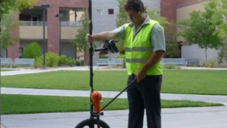
One-step Subsurface Utility Locator
Optimal Ranging, Inc, (ORI, USA) has introduced the Spar, which is a handheld, one-pass, remote sensor capable of locating and GIS mapping in 3D subsurface cable, conduit and pipe with up to centimeter-level accuracy to depths of one meter, decimeter-level accuracy to depths of three meters and sub-meter accuracy to depths of fifteen metres.
The new method is expected to be of interest to surveyors and GIS professionals who are looking to incorporate underground surveys in their work. The Spar operates similarly to a GNSS receiver by incorporating additional sensors just as the GNSS receiver makes use of additional satellites. The unprecedented performance of the Spar is made possible by ORI's proprietary FieldSens remote sensing technology integrated with GNSS-derived geographic positions. The Spar determines the offset and depth of the pipe and automatically merges it with the GNSS geographic position to produce a survey-grade subsurface 3-D map, with estimates of both horizontal and vertical RMS error, in GIS or CAD formats for export.
To locate and begin mapping, the Spar only needs to be brought in proximity to the utility line. It automatically displays the location of the utility on the GIS map interface and guides the operator along the lay line of the utility. The Spar identifies the position of the utility regardless of its orientation to the radiated field, which allows the operator to follow the track even when the utility is behind a fence or covered by impassable vegetation.
The Spar is designed to meet a broad range of applications and can be applied as handheld, pole or cart-mounted. Depending on the job requirements, either a single Spar or dual Spars may be integrated with several levels of GNSS (global navigation satellite system) positioning accuracy. For entry-level applications to depths of three metres requiring decimetre-level accuracy, a single Spar with single L1 frequency GNSS geo-positioning is suitable. For applications requiring centimetre-level accuracy or to depths beyond three metres, a dual Spar configuration and dual-frequency, multi-constellation GNSS is recommended.

Value staying current with geomatics?
Stay on the map with our expertly curated newsletters.
We provide educational insights, industry updates, and inspiring stories to help you learn, grow, and reach your full potential in your field. Don't miss out - subscribe today and ensure you're always informed, educated, and inspired.
Choose your newsletter(s)


