State of the art in 3D city modelling
How does 3D city modelling fit within the context of broader developments such as smart cities and digital twins? And which six challenges must be overcome before 3D data as...
How does 3D city modelling fit within the context of broader developments such as smart cities and digital twins? And which six challenges must be overcome before 3D data as...
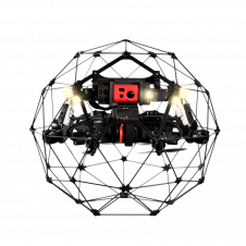
Flyability and Pix4D recently announced a partnership agreement to offer bundled Flyability and Pix4D products. The bundle will be sold in the form of a photogrammetry add-on that can be...

Pix4D will be hosting its flagship conference in Denver, Colorado, on 13 October 2022. The event includes expert guest speakers on 3D modelling and photogrammetry, personal consultations, networking opportunities, the...
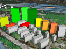
Rapid urban development in China has transformed the cityscapes, with a dramatic increase in high-rise buildings. However, the current 2D property valuation methods neglect the vertical dimension, even though that...
SimActive, one of the leading developers of photogrammetry software, has announced the release of version 8.0 with a new 3D modelling module for Correlator3D. The module allows the generation of...
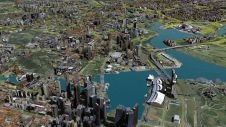
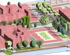
No modern city is future-proof without a ‘digital twin’: the 3D city model. 3D city models are virtual representations of urban environments and include buildings, terrain, infrastructure, landscapes, vegetation and...

As we enter the era of smart manufacturing, the reliability of data is growing in significance and data standardization is becoming increasingly important. According to JP Kelly, associate director and...

Geo Connect Asia (GCA) is set to return to the Sands Expo and Convention Centre in Singapore on 6 March and 7 March 2024. Since its establishment in 2019, GCA...

Normally when something is too good to be true, it is not true. But in the case of dense image matching (DIM), professional surveyors should look twice – because their...

Arithmetica has given visitors at SPAR 3D 2017 an insight into how quick and easy it is to convert the vast point clouds generated by modern laser scanners into manageable...
This site uses cookies. By continuing to use this website, you agree to our Cookies Policy. Agree