Stonex unveils hybrid mobile real-time mapping solution
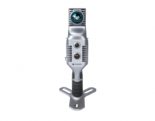
Stonex has launched a new SLAM solution for fast and efficient large-area surveys: the X70GO SLAM laser scanner. It combines mobile scanning with a stationary mode to scan with higher...
Stonex has launched a new SLAM solution for fast and efficient large-area surveys: the X70GO SLAM laser scanner. It combines mobile scanning with a stationary mode to scan with higher...

Stonex is an Italian company, world leader in measurement and surveying. The head office is near Milan and the American headquarters is in Concord, USA. The company also has a...

Founded in 2017, ZZCOMM technology of geospatial hardware and software solutions provides rapid and high-accurate geospatial data for BIM, mining AEC, survey and mapping industries, whether they are indoor, outdoor,...

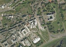
From the skies to the ground, aerial surveying and mapping professionals play a crucial role in capturing, processing, analysing and publishing geospatial data. This article explores the diverse career opportunities...
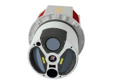
ClearSkies Geomatics, based in Colorado, USA, has recently added the RIEGL VQ-1560 II-S airborne laser scanner to its growing rental system fleet. This laser scanner, an advancement of RIEGL's dual-channel...
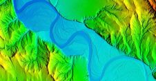
Woolpert has secured a contract with the University of Wyoming to generate a digital terrain model and contours. Leveraging Lidar data previously acquired for the United States Geological Survey (USGS),...

Global reference systems such as the International Terrestrial Reference Frame provide the foundation for determining positions on Earth and in space, as well as for reliably quantifying our planet’s changes...

Lidaretto is flexible and compact Lidar scanning system developed since 2015 and uniquely designed to be used the way that fits best to users’ specific application. You can easily mount...

DiNelly Aerosystems presented its new eXoGyro gyrocopter as a versatile aerial platform for airborne sensing missions at the recent AERO 2013 global aviation fair held in Friedrichshafen, Germany. The eXoGyro...
An aerial photographic survey of Scotland was recently completed by Getmapping. The whole of the country has been made available in digital format, and can be supplied either on disk,...
This site uses cookies. By continuing to use this website, you agree to our Cookies Policy. Agree