Monitoring Coastal Erosion with UAV Lidar
This survey in southern France confirmed the suitability of UAV Lidar for mapping shoreline changes in the context of erosion and drinking water availability. The French Mediterranean coast is a...
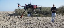
This survey in southern France confirmed the suitability of UAV Lidar for mapping shoreline changes in the context of erosion and drinking water availability. The French Mediterranean coast is a...

Austria-based RIEGL once again introduced a new range of Lidar products at this year’s Intergeo, varying from laser scanners to various software solutions. At the geospatial industry’s leading international trade...
Phase One has launched a major innovation in aerial imaging: the 190MP Aerial System. It is built on the new, dual-CMOS sensor, dual-lens iXU-RS1900 camera, which is capable of capturing images...

YellowScan has put together a diverse agenda for the LiDAR for Drone 2017 User Conference, with YellowScan LiDAR equipment being used in applications such as archeology, forestry, powerlines, surveying, mining...
Applanix has introduced POSPac MMS 8 GNSS-aided inertial post-processing software for georeferencing data collected from cameras, Lidars, multibeam sonar and other sensors on mobile platforms. The announcement was made on...

Lead’Air has developed a new, compact five-camera multi-image digital acquisition system (MIDAS), the Helidas, capable of mounting on the nose of a Bell 206B or AS350 Eurocopter with the use...
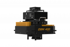
RIEGL has revealed the new VQ-1560i Dual Lidar Channel Airborne Laser Scanning System that is the advancement of the high altitude airborne mapping system LMS-Q1560 that is in current operation...

RIEGL traditionally uses the Intergeo platform to give an insight into and an overview of its comprehensive Lidar sensors and systems product range. This year, on the first day, RIEGL introduced...

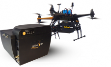
High Precision, Long-Range UAV Lidar & Drone Lidar Mapping Solutions At YellowScan, we design, develop and build Lidar solutions for professionals that require performance, robustness and accuracy. Our hardware and...
YellowScan has put together a diverse agenda for the YellowScan Lidar for Drone 2016 User Conference. The topics on the programme prove the broad usage of YellowScan Lidar equipment in...
This site uses cookies. By continuing to use this website, you agree to our Cookies Policy. Agree