Multibeam Lidar for Mobile Mapping Systems
Various multibeam Lidar sensors are suited for mobile mapping. Read this article to learn more about their features and productivity. In mobile mapping, geospatial data is acquired by one or...
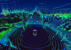
Various multibeam Lidar sensors are suited for mobile mapping. Read this article to learn more about their features and productivity. In mobile mapping, geospatial data is acquired by one or...
Global technology company Emesent has announced the release of the colourization functionality for its Hovermap Lidar scanner. The 3D point clouds from Hovermap can now be augmented with true colour,...
Previously, people had to invest more than 30,000 dollars to purchase professional mapping drones and place a large number of control points on the ground to get accurate, survey-grade maps....
The use of 3D laser scanners is expanding the role of geospatial technology in criminal investigations. The technology is being used to produce accurate, feature-rich visualizations of crime scenes that...
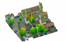
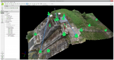
A UAV project in Germany has integrated photogrammetric bundle block adjustment with direct georeferencing of Lidar point clouds to considerably improve the respective accuracy. Recent unmanned aerial vehicle (UAV or...

A simple inspection of still-existing Roman roads, aqueducts and canals shows that the Romans were exceptionally skilled engineers. Shoe sizes provide a person’s shoe fitting size. There are many different...
The skills that engineering surveyors had to acquire in order to respond to the challenges of the construction world have made them capable, also, of fulfilling other challenges, several of...
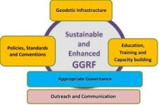
FIG Commission 5 focuses on meeting the highest level of accuracy for Positioning and Measurement. It provides the tools, techniques and procedures to educate and train surveying professionals everywhere. Appropriate...

Switzerland-based photogrammetry leader Pix4D has released its next-generation software suite addressing the modern-day geospatial professional challenges. Developed in close collaboration with customers and partners, Pix4Dsurvey, Pix4Dmatic, Pix4Dinspect and Pix4Dscan will...
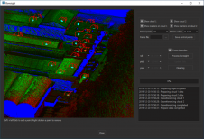
3D Target has announced the release of its SmartProcessing Lidar 1.2 software solution. SmartProcessing Lidar, fully developed by 3D Target, enables the production of high-quality georeferenced point clouds from the...
This site uses cookies. By continuing to use this website, you agree to our Cookies Policy. Agree