Ordnance Survey Selects Bluesky for New Framework
Bluesky International has been named as one of the selected organizations to sit on a new framework created by Ordnance Survey. The Remote Sensing Acquisition Framework has been set up...
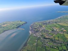
Bluesky International has been named as one of the selected organizations to sit on a new framework created by Ordnance Survey. The Remote Sensing Acquisition Framework has been set up...

Ronald Koomans studied geology at Utrecht University and did his PhD at the nuclear physics lab of the University of Groningen on the application of an underwater gamma-ray spectrometer to...
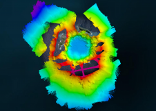
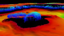
The Tonga Eruption Seabed Mapping Project (TESMaP) is a collaborative mission to discover the undersea impacts of the January 2022 eruption of the Hunga-Tonga Hunga-Ha’apai volcano. Using their collective knowledge,...
Hydrographers are increasingly aware of the added value that a Lidar (Light Detection and Ranging) scanner can bring to bathymetry survey operations. The Teledyne Optech Polaris Laser Scanner, for example,...

The twelfth session of the United Nations Committee of Experts on Global Geospatial Information Management (UN-GGIM) was held from 1-5 August 2022 at the United Nations headquarters in New York,...

Dr Diane Dumashie won the final vote at the FIG Congress 2022 in Warsaw and will serve as the next president of FIG for the next four years. She stated...
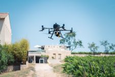
Attendees of YellowScan's recent Lidar for Drone 2022 Conference headed home with a backpack full of inspiration, according to Wim van Wegen. A relaxed vibe, sunny weather with summer temperatures,...
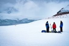
Capturing and measuring the environment in the Arctic and Antarctic is a particularly challenging job. The area of interest is often covered by a thick blanket of snow and ice,...
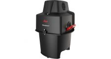
Leica Geosystems, part of Hexagon, has announced the introduction of Leica Chiroptera-5, the new high-performance airborne bathymetric Lidar sensor for coastal and inland water surveys. This latest mapping technology increases...
The U.S. Geological Survey has contracted with Woolpert to conduct a high-precision geophysical survey and subsurface geologic mapping in Arkansas. The firm will collect, process and deliver high-resolution airborne radiometric...
This site uses cookies. By continuing to use this website, you agree to our Cookies Policy. Agree