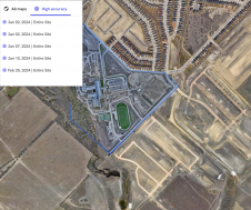
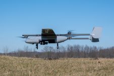
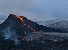
Found 2266 results
Sort by

Lidar in surveying & mapping

Lidar, short for Light Detection and Ranging surveying, represents a sophisticated measuring system leveraging the power of light. Widely recognized for its versatility, Lidar is extensively applied in diverse fields...

Read more

Stonex

Stonex is an Italian company, world leader in measurement and surveying. The head office is near Milan and the American headquarters is in Concord, USA. The company also has a...

Read more

Lidaretto

Lidaretto is flexible and compact Lidar scanning system developed since 2015 and uniquely designed to be used the way that fits best to users’ specific application. You can easily mount...

Read more

What’s new in Global Mapper Pro v25?

Blue Marble Geographic’s flagship software, Global Mapper Pro, is an all-in-one GIS package for analysing and processing vector, terrain, image and point cloud data. Compatible with over 380 different file...

Read more

Joël van Cranenbroeck

Joël van Cranenbroeck is a geodesist, founder of CGEOS Creative Geosensing SRL and scientific advisor at the University of Liège, Belgium. He has extensive experience at institutions like the National...

Read more