Data Management Services
Easy access to repositories of space-borne imagery and other geospatial data is becoming increasingly important now that sensors are able to produce petabytes of data in the blink of an...

Easy access to repositories of space-borne imagery and other geospatial data is becoming increasingly important now that sensors are able to produce petabytes of data in the blink of an...

Maxar Intelligence has been awarded a contract to supply the National Geospatial-Intelligence Agency (NGA) with a Precision3D Data Suite bundle. This comprehensive package covers an extensive area of 160,000 square...

SuperGeo Technologies, Taiwan, has launched SuperGIS data management tools including SuperGIS DataManager 3.1, SuperGIS DataConvertor 3.1 and SuperGIS DataRectifier 3.1. These SuperGIS data management tools will be built into SuperGIS...

Especially for the construction industry, 12d Solutions have developed 12d Field. This software module allows users to view and utilise entire project models in the field, enjoy real-time set out...
Registration for the 1Spatial Conference 2008: '1 Source of Truth' is now open. The Conference will take place from 29th April to 1st May at the Radisson SAS Hotel, Stansted...

The Icelandic authorities have commissioned Acecore to map the extent and aftermath of the Eldvörp-Svartsengi volcanic system eruption using its high-end drone solutions. Grindavík, a fishing village on the Reykjanes...
PlanetScope is now accessible on Google Cloud Marketplace. This availability of Planet's flagship satellite imaging product contributes to the company's mission to democratize access to near-daily satellite imagery, enabling organizations...
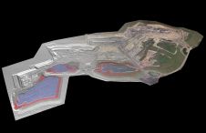
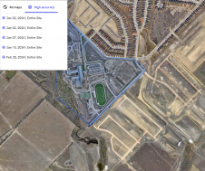
At Geo Week 2024 in Denver, Maptek unveiled its latest innovation: Maptek GeoSpatial Manager. This groundbreaking solution simplifies and streamlines workflows, revolutionizing how mining and civil engineering projects manage data...
Trimble has unveiled the integration of the Trimble Applanix POSPac Cloud post-processed kinematic (PPK) GNSS positioning service, featuring CenterPoint RTX, with the UAV-based mapping and data collection capabilities of DroneDeploy’s reality...
This site uses cookies. By continuing to use this website, you agree to our Cookies Policy. Agree