Erich Nau
Erich Nau is a researcher at the Norwegian Institute for Cultural Heritage (NIKU), specializing in 3D documentation and geophysical survey techniques for cultural heritage. With a focus on methodological development,...

Erich Nau is a researcher at the Norwegian Institute for Cultural Heritage (NIKU), specializing in 3D documentation and geophysical survey techniques for cultural heritage. With a focus on methodological development,...

The Dutch startup Aerial Precision recently demonstrated its first two sensors with integrated artificial intelligence software. Over the past few years, the company’s innovation efforts have resulted in products that...
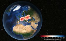
Europe is suffering from a severe drought. Satellite data analysed at TU Graz's Institute of Geodesy confirms that groundwater levels have been consistently low since 2018. Although extreme weather events...
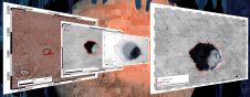
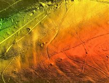
Can we leave the mapping of the planets and moons in our solar system to AI-powered systems? The answer seems to be ‘yes’, as scientists have now developed a novel,...

Han Limburg studied physics at the University of Groningen and completed his PhD (cum laude) in the atomic physics group of the nuclear physics lab there. Limburg subsequently worked at...
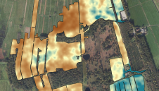
The Earth sciences sector is rapidly adopting UAVs. These two studies have explored combining a gamma-ray spectrometer with a drone to map soil properties. In the Earth sciences sector, sensors...

FairFleet has won a four-year framework contract to provide unmanned aerial services for the Copernicus Emergency Management Service. The contract was awarded by the Joint Research Center of the European...
Lidar owes its growing popularity to the accuracy and high resolution with which it maps the environment. Continued technological advances are resulting in even better usability, reliability and sustainability, while...

SPH Engineering has announced the third generation of the UgCS SkyHub hardware and released the largest update of the UgCS SkyHub software ever. The development accumulates five years of knowledge...
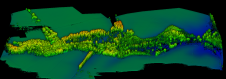
A high-precision terrain mapping project has revealed more than 400 ‘new’ archaeological sites in England’s first Area of Outstanding Natural Beauty (AONB). Commissioned by the Quantock Landscape Partnership Scheme (QLPS)...
This site uses cookies. By continuing to use this website, you agree to our Cookies Policy. Agree