Optimal GCPs with Onboard GPS
The collection of Ground Control Points (GCP) for block adjustment is a costly and time-consuming operation. Onboard GPS enables a reduction in the number of GCPs without loss of accuracy....
The collection of Ground Control Points (GCP) for block adjustment is a costly and time-consuming operation. Onboard GPS enables a reduction in the number of GCPs without loss of accuracy....
‘Knowledge and Action for the Earth’ is the theme of Intergeo 2006, the annual geodesy and geo-information conference and trade-fair organised in association with the German Association of Surveying (DVW)...
Info-Dynamics Research Associates Ltd (I-DRA) are engaged in a number of standards and interoperability activities, including a recently funded INSPIRE-GMES data harmonisation project within the European Union 6th RTD Framework...
SBG, a Sweden-based privately owned company, designs and manufactures software and hardware for survey, design, and machine-control applications. Since its inception in 1970 the company has provided surveying tools for...
During the past year the Faculty of Geodesy at the University of Zagreb has introduced fundamental reform of all its education programmes, undergraduate, graduate and postgraduate doctoral studies, and established...
Eight out of ten mergers end in failure. And that’s even a bit optimistic; it might be more. The fact is that a merger designed to yield added value is...
Initiated at Delft University of Technology in the Netherlands, CycloMedia has evolved into an international organisation. For many years the company has been a major player in large-scale, systematic visualisation...

Colortrac began shipping the SmartLF Gx+ 56 extra-wide format scanners in March 2009; the first scanners in the all-new SmartLF Gx+ large-format scanner range. Now, two new Gx+ scanner models...

The use of Mobile Lidar systems enters the scene when large areas have to be surveyed at accuracy and resolution exceeding those available through aerial photogrammetry, and when using static...
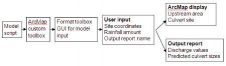
Estimating rainfall discharge is difficult in large catchment areas with varying topography. This leads to widespread inadequacy in culvert design, with resultant damage to these and other drainage infrastructure during...
This site uses cookies. By continuing to use this website, you agree to our Cookies Policy. Agree