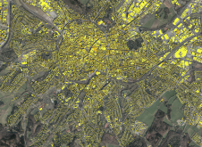
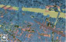
Use of AI to detect rooftop solar potential
Global climate change and, in some areas, the lack of a cheap and reliable energy supply are contributing to the expansion of photovoltaics, both regionally and worldwide. In addition to...
Global climate change and, in some areas, the lack of a cheap and reliable energy supply are contributing to the expansion of photovoltaics, both regionally and worldwide. In addition to...
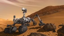
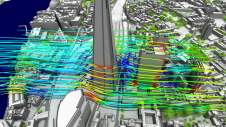
A new Lidar technique could help robotic vehicles avoid hazards when landing during future space missions to Mars or the Moon. The method uses flash Lidar to record full 3D...
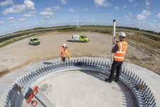
As the impacts of climate change become increasingly evident, this article zooms in on how the geospatial industry can play a meaningful role by providing accurate data and analysis to...
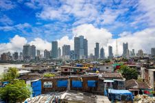
This article explores how some government initiatives in India are utilizing geospatial technologies for better outcomes. The rapid pace of urbanization in India has been an instrument of socioeconomic, political...
Can digital twins help cities face challenges ranging from sustainability to education, and from infrastructure to healthcare? While digital twin techniques have been applied successfully in manufacturing and construction, cities...
Vodafone has partnered with Esri to create a digital twin of its network of mobile masts. This will enable real-time monitoring of the network, helping to ensure the best possible...
Perhaps surprisingly, video game development is becoming an increasingly popular use case for navigation and Lidar data. However, it is often overlooked amidst the almost endless possible applications for 3D...

At Intergeo 2022, 'GIM International' caught up with Jürgen Dold, at that time EVP of Hexagon, to hear his thoughts on the key changes in the geospatial sector. Jürgen Dold,...

“We are on a highway to climate hell,” said Antonio Guterres at COP27. So how can the geospatial industry help society to find the nearest exit? Despite certain people still...

R-evolution has been awarded a contract to supply multidimensional intelligent mapping services of The Bahamas’ seabed. The services are part of a larger initiative to enable the island nation to...
This site uses cookies. By continuing to use this website, you agree to our Cookies Policy. Agree