Can digital twin techniques serve city needs?
European cities face sustainability challenges and more
Can digital twins help cities face challenges ranging from sustainability to education, and from infrastructure to healthcare?
While digital twin techniques have been applied successfully in manufacturing and construction, cities are so complex that they require more measuring and modelling effort. Moreover, since they are evolving all the time, it is not enough to simply measure and model cities only once. This article explores whether digital twin techniques can meet city planning needs and help them face their wide-ranging challenges – from sustainability to education, digitalization, infrastructure and healthcare.
Humans have planned their actions since time immemorial, and with good reason: planning saves time, money and effort. In today’s digital era, paper maps have been replaced by 3D digital models. The need for digital twin (DT) techniques originates from this continuous quest for better and more precise planning of actions and resource allocation. DT techniques have been applied successfully in manufacturing and construction, but this is no guarantee for success in city planning. Cities are so big and complex that it takes significant effort to measure and model them. Therefore, typically, only a part of the city (e.g. a building) is measured and modelled at a time. Moreover, any single act of measuring and modelling a city is not enough, since cities are never complete but keep on evolving. Hence, for cities, the question is: can the DT techniques answer to their needs?
So what do cities need? To understand this question, it is first necessary to elaborate what a city entails. Typically, the city council formulates the needs of a city into a vision and a strategy, in a language that can be understood by the civil society. This article is written from a European perspective. Both authors have been acting councillors in Europe’s most sustainable city: Espoo, a part of the Helsinki metropolitan area in Finland. Additionally, one of the authors has been the president of the European Committee of the Regions, i.e. the assembly of regions and cities involved in official EU decision-making.
City needs
Cities share some needs and objectives. Common needs have been identified, e.g. in the 2030 Agenda for Sustainable Development, which has been adopted by all United Nations Member States since 2015. State governments have committed, which is good. But commitment must also exist at the city level, where the practical measures are developed and implemented, and impact is made. This is underlined by the European Commission’s call for ‘multi-level governance’: EU Member State/city collaboration.
All cities share the need for funds for yearly budgeting and investment plans. City councils are also kept busy by new emerging needs, such as new challenges in education, investments needed for digitalization and infrastructure, and increasing costs for better healthcare.
City as a Service
In Espoo, for instance, the vision established by the city council is to run the city as a service (CaaS). What does this mean? The as-a-service concept originated as an information communication technologies (ICT) business model for offering information technology and software. It means acknowledging that a city cannot answer to every need of its citizens based on the work done by city officials. Instead, services are provided by the entire city community, not just the official city organization. Companies and other communities will be part of the innovative urban ecosystem and service provision. Hence, the city wants to be a facilitator and a platform in enabling the civil society to find solutions for the existing challenges.
The CaaS model builds on transparency, opening processes and data, and a high level of digitalization, including running processes in cloud. Open interfaces yielding data enable the emergence of new businesses that can target specific needs of the civil society. Moreover, this transparency supports democracy, while digitalization offers efficiency and inclusivity. Because it does not require things to be run through the city office, the CaaS model is scalable, thus facilitating city growth. It means deploying ICT as a vehicle for catalyzing smart city innovation. The city offers a digital platform on which actors of civil society, such as businesses, universities, NGOs and citizens, can develop solutions to improve wellbeing. City DTs should also be available through this platform.
Better city planning
The value of property owned by a city is typically huge, but it is tied up in infrastructure and buildings. DT technologies can play a key role in asset and facility management by reaping more returns on these investments. Currently, the techniques are used for road asset inventorying purposes and some smart traffic applications during rush hours, for example. Next-level questions include an overall better planning of the city. For instance, in the past, city districts were planned for singular functions: one area for working, one area for sleeping, one area for education activities. An example of this could be found in Espoo, where the campus of Aalto University, the ‘garden city’ of Tapiola and the high-tech industrial zone of Keilaniemi were all disconnected and separated by highways. The city council has worked persistently for decades to find solutions to integrate these city districts and to procure the needed investment funding for projects such as tunnelling the highways. Integration activities have also included extending the metro line from downtown Helsinki to Espoo in the west and building a light rail system. This means providing public transport infrastructure to connect city districts by rail.
Against this backdrop, many DT-related questions arise, such as how to increase the utilization rates and what is the best way to further improve the multi-functional city districts? Should a city library be inside a mall? What about a public health centre? Even though multi-functional city districts offer more possibilities and a better quality of life for the citizens, they also make further improvements harder, because the systematic complexity is increased. This is where DTs can come in useful. Therefore, the need for advanced DT techniques will continue to increase, as city councils demand and seek more usability value for the city infrastructure and buildings.
Digitalization
Digitalization has been a beneficial process of change for cities. In Espoo, it has had great impact on processes in the central administration and within the city departments. Also, it has shown remarkable results for breakthrough and potential for supporting the Sustainable Development Goals (SDGs). Because digitalization is beneficial, the EU is also pushing digital transformation forward with its programmes.
However, what has not changed is the paradigm of digitalization being seen as an ICT item and being owned by ICT people. The ICT processes often reside in silos. Cities have their ICT departments and ICT tools, wherein the information exists and benefits the work of individual experts. Crucially, what is lacking is the integration of this information into common tools for all planning and development. ICT has not yet been used to its fullest extent: to enable the joint planning between different functions. City DTs can be expected to take this role, in which the ICT acts as a tool for enabling multi-level governance – not only in the traditional state/city sense, but in the sense that also the bureaucratic levels inside cities could become more effective.
The most critical step to take is to make city DTs useful for people who are neither digital natives nor IT-oriented. City planning, for instance, must be inclusive for all stakeholders. The past, the present and the future must be presented in an understandable form. The vision for a citizen’s home neighbourhood must be comprehensible to them. It should be a continuous story of what was and what will be, with the concrete next steps. This requires a human factor perspective in the design of the interaction with the DT and suitable understanding of the interface through which the digital information in the DT can be viewed. Only then can the DT systems effectively support decision-making in a city.
Manageable ecosystems
This human-centric planning, rather than ICT-centric planning, will be the ultimate success story of city DTs. Human-centric planning allows for ecosystem management, jointly with the stakeholders. And that is what a smart city district is: an ecosystem of a manageable size. In Espoo, there are two pioneering areas for this kind of development – the above-mentioned Otaniemi-Tapiola-Keilaniemi area and Kera – both of which are several square kilometres in size.
Kera was initially a single-function city district – a logistical area of warehouses and other industries with a loosely built high-tech industrial zone (including for example Nokia’s research centre with its 5G test area). A planned development process is intended to transform the area into a vivid multi-functional city district and a Europe-wide pioneer of successful implementation of the circular economy and associated digitalization. Specific objectives include optimal resourcing of maintenance, e.g. waste recycling, and snow ploughing in wintertime, and optimal allocation of facilities for different city and third-party functions. The platform for this ecosystem is CaaS. Any process for change should be describable within this platform. Changes requiring people from different organizations and branches of administration to participate become tangible if the process for change awakens people that they can and want to participate and influence the process. DT techniques should fulfil their part here.
Evolving technologies
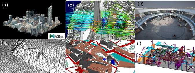
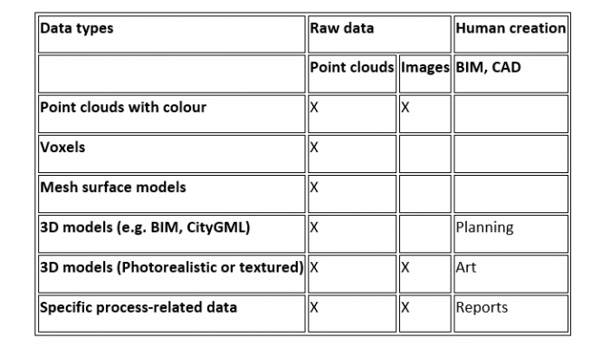
City DTs have two origins. On the one hand, building information modelling (BIM) techniques developed for individual buildings can be expanded to describe whole cities. On the other hand, geoinformation systems (GIS) have evolved from 2D maps towards 3D modelling of not only landscapes, but also cities. Taking the best from both worlds – in respect to standards, methods and data – arguably leads to the best way of creating city DTs. Needless to say, while BIM and GIS offer only 3D models, a digital twin does more than that.
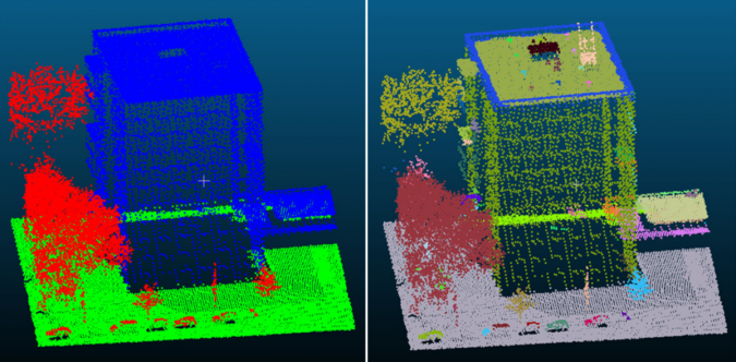
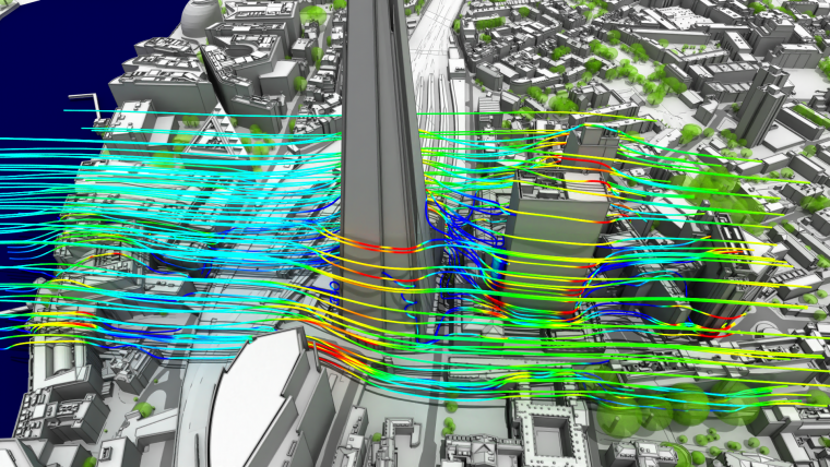
Digital twins share a common identity under the DT umbrella. However, the current DTs for different city applications can be technically very different, both method-wise and data-wise (images, point clouds, polygonal models, etc.). This is because the individual techniques are aimed at specific technical or planning objectives. Turning individual planning activities into joint planning efforts would ideally require gathering all information together and then sharing it between the parties. To use computer science terminology, a back-end city DT could act as the container of all information, while any single front-end interface, whether visualized for use by humans or designed for use by robots, would offer a limited but meaningful representation of the DT for a specific application. The back-end DT (or any specific DT) could be updated autonomously from sensor data using artificial intelligence techniques, and the front ends could offer large benefits to the entire city ecosystem.
Automated updates
Updating DTs is important because decisions should always be made with the very latest information. If the updating of technical models is done by humans, the financial cost is high. Moreover, there is no catalyst for joint planning, whereas joint planning using DTs immediately becomes attractive if the updating is done automatically by a computer. The key innovations for automated updates come from the field of artificial intelligence (AI). Data captured by Internet of Things (IoT) sensors, field survey sensors or other platforms and applications can be transformed into information that is meaningful for the DT and for the applications it serves. This is a game changer. While AI research has gone through multiple hype cycles over the past 50 years, today it is as if a missing piece of the puzzle has fallen into place. In principle, the AI methods can be applied to labelled objects from point clouds and images, and these labelled objects can then be matched against the respective elements in BIM and GIS models. In practice, however, a lot of research is still needed.
Human factors and joint planning
Cities are complex systems, which need to be planned jointly with various stakeholders. Therefore, it is essential to include a human-factor perspective to identify the potential advantages and the future use of DT systems to support city decision-making. When it comes to joint planning, the benefits of interacting with DTs can be ensured only by safe and usable systems that enable agents to visualize and share information appropriately. The current cave-at of the BIM and GIS tools is that they are utilized and developed as IT tools for IT-oriented people. These tools are not suitable for broader use, but new tools are needed for joint planning.
Conclusion
It is time for action in the cities of Europe. The relevant body for cities, the EU’s Committee of Regions, wants the quality and amount of data provided by the public sector to be improved to speed up the transformation to the digital economy. It is right to want more digitalization because digitalization is beneficial. But the focus in DTs must change from ICT-centric to human-centric, to keep the objectives up to date.
The needs of a city change over time, as illustrated by the relatively recent introduction of the SDGs or the EU’s digital programmes. The changes can be a subtle shift in the focal point rather than a full turnaround. City needs are complex, reflecting the demography of the specific city and the individual needs of its citizens. Current DT techniques are focused on the physical side of a city and are therefore unable to forecast changes in needs. That is why DT techniques should be developed further to also include human factors. In particular, the psychological aspects of a neighbourhood and of a city are very important in many regards. The effects of these are clearly visible in real-estate pricing, for example, but the data does not explain the reason behind the pricing. Ideally, DT techniques would offer ways to also encapsulate this tacit information and offer predictions for how it would change in the case of different planning scenarios.
Further reading
Lehtola, V. V., Koeva, M., Elberink, S. O., Raposo, P., Virtanen, J. P., Vahdatikhaki, F., & Borsci, S. (2022). Digital twin of a city: Review of technology serving city needs. International Journal of Applied Earth Observation and Geoinformation, Volume 114, 102915, https://doi.org/10.1016/j.jag.2022.102915
City of Espoo’s Digital Agenda, https://www.espoo.fi/en/city-espoo/innovative-espoo/digital-agenda
Matos, F., Vairinhos, V., Salavisa, I., Edvinsson, L., & Massaro, M. (2020). Knowledge, People, and Digital Transformation. Springer
Tomljenovic et al, Remote Sens. 7 (4) (2015) pp. 3826-3862, drone: Flaticon.com
Karam et al, ISPRS Journal of Photogrammetry and Remote Sensing 181 (2021): 413-426
Jaalama et al, Landscape and Urban Planning 207 (2021): 103996
Yang et al., Remote Sensing 12.5 (2020)
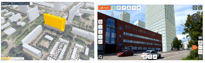
xD Visuals Oy: xD Twin solution, https://www.xd-twin.io/


Value staying current with geomatics?
Stay on the map with our expertly curated newsletters.
We provide educational insights, industry updates, and inspiring stories to help you learn, grow, and reach your full potential in your field. Don't miss out - subscribe today and ensure you're always informed, educated, and inspired.
Choose your newsletter(s)


