New Frontiers for Geomatics
Over the next decade, the real-time smart city is likely to become a reality in many of the world’s cities. Co-ordination, communication, coupling and integration are all different methods involved...

Over the next decade, the real-time smart city is likely to become a reality in many of the world’s cities. Co-ordination, communication, coupling and integration are all different methods involved...
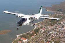
Diamond Aircraft, Austria, has introduced the new DA42 GEOSTAR that enables the collection of laser scanning and photo-grammetry data during one single flight. The team of Diamond Airborne Sensing (subsidiary...
This year, Intergeo is being held just a stone’s throw away from the Essen Mühlheim Airport in Germany. Airborne Technologies plans to use this opportunity to bring one of its...
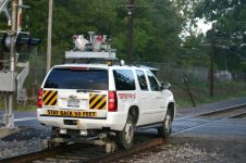
Mobile mapping system StreetMapper has been used to collect design-grade 3D data for a rail improvement project in New York, USA. Supplied by 3D Laser Mapping, StreetMapper uses a series...

Experts in laser scanning from around the world recently came together to witness the latest technical innovations and solutions at a one-day event in London, UK. Organised by 3D Laser...
IGI, Germany, and Phase One, USA, have announced that the flight planning software, IGIplan, and the flight guidance and sensor management system, CCNS-5, now support the Phase One iXA aerial...
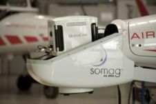
South African GeoM (formerly Geomatica) has invested in a navigation system designed to improve the locational accuracy and reliability of aerial survey data. The purchase of a 5th-generation Computer Controlled...

Experts in laser scanning from around the world will come together to showcase the latest technical innovations and solutions at a one-day conference in London, UK. The free-to-attend event, organised...
In collaboration with University College London, 3D Laser Mapping will organise its first-ever laser scanning product showcase. There is no charge to attend this event, which will feature the latest...
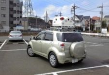
Japan has recently taken delivery of its sixth mobile laser mapping system from 3D Laser Mapping. StreetMapper, a mobile laser mapping system, uses vehicle-mounted sensors to achieve highly accurate measurements...
This site uses cookies. By continuing to use this website, you agree to our Cookies Policy. Agree