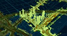
Reconstructing 3D buildings using deep learning
How can artificial intelligence and deep learning lead to a robust process for 3D city modelling? And what are some of the challenges? Automated classification and object detection in Lidar...
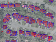
How can artificial intelligence and deep learning lead to a robust process for 3D city modelling? And what are some of the challenges? Automated classification and object detection in Lidar...

Read this guide to the main 3D data representation methods to understand the key differences and choose the best method for your specific applications. The 3D data jungle in today’s...
Woolpert has been selected to collect, process and deliver topographic mapping across more than one quarter of Nigeria, or roughly 258,000 square kilometres, under a US$4.4 million contract with the...
When it comes to monitoring the condition of roads, UAV technology can overcome many of the downsides associated with traditional methods, which can be time-consuming, labour-intensive and sometimes subjective. This...
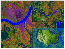
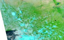
Land Info Worldwide Mapping recently completed up-to-date 10m-resolution thematic raster GIS data covering all 50 US states. Optimized for low-band (broad-area coverage) 5G wireless planning, the dataset supports additional applications including...
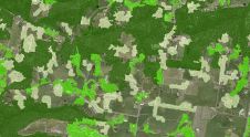
Thanks to machine learning, Victoria's Department of Environment, Land, Water and Planning (DELWP) is making it easier than ever before to get information about the tree cover extent state-wide. Victoria...
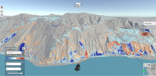
Lidar change detection (LCD) is one of the most capable techniques for mapping changing terrain through time. It can be applied in billion-dollar decisions to design, build and operate tunnels,...
Woolpert has acquired AAM, a global geospatial services company that specializes in aerial mapping, surveying, GIS and the development of innovative geospatial processes and technologies. AAM is headquartered in Australia...
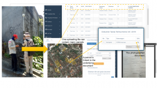
A mobile app has been developed to improve the success of cadastral survey implementation in Indonesia. The country has set itself ambitious land registration targets by 2025. The national cadastral...
PlanetObserver and Kalisio have revealed My Planet Maps, a new subscription-based online map service that delivers immediate streaming access to fresh and global data. It includes performant vector and raster georeferenced basemaps....
This site uses cookies. By continuing to use this website, you agree to our Cookies Policy. Agree