Continuous Mobile Laser Scanning
Combining Terrestrial Laser Scanning, Position and Orientation Systems and GPS receivers into a mobile mapping system enables effective mapping of large and complex terrain. The authors tested a mobile mapping...
Combining Terrestrial Laser Scanning, Position and Orientation Systems and GPS receivers into a mobile mapping system enables effective mapping of large and complex terrain. The authors tested a mobile mapping...
From 30th September to 2nd October, geodesy, geoinformation and land management took centre stage in Bremen, Germany. Intergeo 2008, organised by HINTE GmbH in association with the German Association of...
Airborne 1 Corporation (CA, USA) has purchased its fourth Optech ALTM sensor and filled the position of CFO. Airborne 1 has purchased a new Optech ALTM sensor to further expand...
Infoterra Ltd (UK) has launched Rapid Surveyor, a new mobile laser mapping system. Infoterra has invested in the next-generation of laser technology, specifically designed for mobile use, to enable the...
MAPPS (VA, USA) has announced that George Southard, Vice President Americas Digital Imaging of Leica Geosystems, Englewood, CO has been elected chairman of the newly formed MAPPS Associate Members Committee....
In 1996 staff of what would become Southern Mapping Company, based in Johannesburg, South Africa, were among the first in the world to offer commercial aerial Lidar (light detection and...
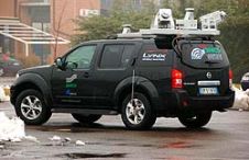
The use of Mobile Lidar systems enters the scene when large areas have to be surveyed at accuracy and resolution exceeding those available through aerial photogrammetry, and when using static...
Optech Incorporated (Canada) has introduced DASHMap, the latest data processing software development for Optech’s Airborne Laser Terrain Mapper (ALTM) product line. DASHMap is Optech’s next generation data processing software for...
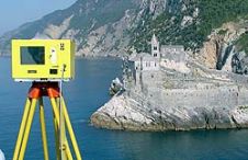
When surveying the coastline, the integration of bathymetric (below sea level) and laser scanning (above sea level) data causes problems due to the different imaging properties. However, by ensuring that...
Intergeo, the world’s largest congress and trade-fair for geodesy, geoinformation and land management, will this year be held in Karlsruhe, Germany, from 22nd to 24th September. About 16,000 visitors are...
This site uses cookies. By continuing to use this website, you agree to our Cookies Policy. Agree