FIG: Setting the Scene for the Coming Four Years
The FIG Congress 2022 marks the end of the current leadership term (2019-2022) for the president, two vice presidents and all ten commission chairs. It has been an unusual –...

The FIG Congress 2022 marks the end of the current leadership term (2019-2022) for the president, two vice presidents and all ten commission chairs. It has been an unusual –...
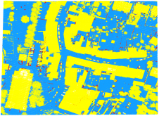
As a division of machine learning, deep learning (DL) has been achieving unparalleled success in image processing and recently demonstrated huge potential for point cloud analysis. Precise ground surface topography...
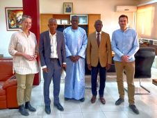
A consortium under the lead of GAF AG will implement the “Programme de Modernisation de la Gestion Foncière” (PROMOGEF), the Land Rights Administration Modernisation Programme of the Senegalese Government and...

The FIG community is counting down until it can finally meet again in person, from 11-15 September 2022 in Warsaw, the beautiful and vibrant capital city of Poland. The FIG...
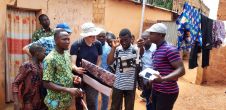
Benin is a stable, French-speaking country in Western Africa. Despite a new modern national law on land administration, the progress of registered parcels is slow. Financed by the Dutch embassy...
Jing Sun is a PhD candidate in geodesy at the Department of Real Estate and Construction Management of the KTH Royal Institute of Technology, Stockholm, Sweden. Her research interests include...
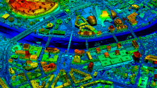
Kartverket, the Norwegian mapping authority, is using airborne Lidar scanning in a project for the territory of North Macedonia. The resulting highly accurate digital elevation models will be distributed to...

Prof Abbas Rajabifard is director of the University of Melbourne’s Centre for SDIs and Land Administration (CSDILA) and chair of the UN-GGIM Academic Network. He is a land and geospatial...
The Open Geospatial Consortium (OGC) has announced that the OGC Membership has approved the CityGML v3.0 Conceptual Model for adoption as an official OGC Standard. Since its first publication by...

EuroGeographics has reaffirmed its commitment to using its expertise in authoritative data to help strengthen the global geospatial infrastructure. At the 11th Session of the United Nations Committee of Experts on Global...
This site uses cookies. By continuing to use this website, you agree to our Cookies Policy. Agree