Bridging the gap between geospatial and construction
Although it is difficult to entirely close the gap between geospatial and construction data, building information modelling (BIM) could help to narrow it. This article explains how. There is a...
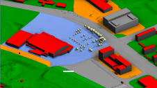
Although it is difficult to entirely close the gap between geospatial and construction data, building information modelling (BIM) could help to narrow it. This article explains how. There is a...
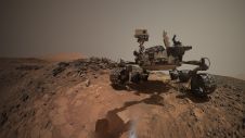
The International Lidar Mapping Forum (ILMF) has announced that Dr. Michael Zanetti, Planetary Scientist at NASA’s Marshall Space Flight Center, will give a keynote presentation titled Bringing Light (Detection and Ranging) into...

Read this interview with five pioneers in the field for insights into the best ways to introduce drones into your business model. Unmanned aerial vehicles (UAVs or 'drones') are increasingly...

Group 42, an artificial intelligence (AI) and cloud computing firm based in Abu Dhabi, UAE, has acquired Bayanat for Mapping and Surveying Services LLC, a provider of customized geospatial data...
Denmark has challenging seascapes to map and chart. It has a rich history of nautical charting that dates back to the seventeenth century, and many of its navigational products for...

Facilitating access to geospatial information from official national sources is in the public interest and supports the public good say members of EuroGeographics. European National Mapping, Cadastral and Land Registration...

The 30th International Cartographic Conference (ICC) will take place in Florence, Italy, in 2021, and is provisionally scheduled for 19-23 July (although these dates are still subject to change). The...

The Netherlands’ Cadastre, Land Registry and Mapping Agency, was the first mapping authority in the world to fully automate the production of multiscale maps and data. This was a huge...

Jochen Schiewe is a professor of geoinformatics and geovisualization at HafenCity University Hamburg, Germany, vice-president of the German Cartographic Society (DGfK) and chair of the DGfK Commission on Cartography and...

Choropleth maps are widely used for presenting population density, social index or other normalized statistical values related to spatial units. One of the ‘white spots’ on the research and development...
This site uses cookies. By continuing to use this website, you agree to our Cookies Policy. Agree