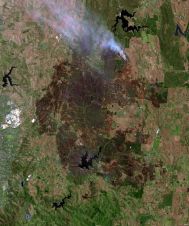
Adelaide Hills Fires Image Captured by Landsat 8
Fires continue to burn across parts of South Australia as the heatwave emanating from central Australia raises temperatures in the region. This satellite image of the Adelaide Hills fires, taken...
Fires continue to burn across parts of South Australia as the heatwave emanating from central Australia raises temperatures in the region. This satellite image of the Adelaide Hills fires, taken...
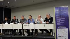
GISTAM 2015, the 1st International Conference on Geographical Information Systems Theory, Applications and Management took place in Barcelona, Spain, from 28 to 30 April. GISTAM 2015 was held in conjunction...
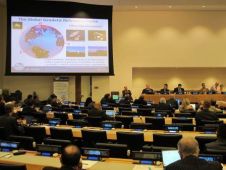
The 3rd meeting of the United Nations Committee of Experts on Global Geospatial Information Management (UN-GGIM) met at the UN Headquarters in New York, USA, from 6-8 August 2014. The...
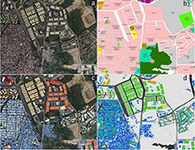
Geoscience Australia has released new open source software, produced as part of a recently completed international capacity-building project in the Philippines, which can rapidly and remotely assess the geometric properties...
During the US shutdown, around half of the more than 5,500 GPS datasets processed with the aid of Geoscience Australia’s AUSPOS global positioning system were from institutions and individuals based...
The Open Geospatial Consortium (OGC) is seeking comments on the charter for a new OGC Big Data Domain Working Group (DWG). Big Data is an umbrella term denoting the digital...
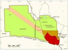
New gravity data obtained in the Woomera Prohibited Area in South Australia has been released. The gravity data was collected by Geoscience Australia on behalf of the Geological Survey of...

World-renowned scientists and engineers are set to meet at the Melbourne Convention and Exhibition Centre, Australia, from 21 to 26 July for this year’s IEEE International Geoscience and Remote Sensing...
Global Scan Technologies, United Arab Emirates, is organising a workshop on Hyperspectral Remote Sensing and Image Processing. The workshop will be held on Monday 6 May 2013 at the Al...

An environmental scientist and entrepreneur who revolutionised the use of geospatial technology for conservation has been awarded the 2013 Champions of the Earth Award, the UN’s highest environmental accolade. Jack...
This site uses cookies. By continuing to use this website, you agree to our Cookies Policy. Agree