Cartomorphosis: an evolution that starts with cadastre
Over the past 15 years, geospatial information has enabled the transformation of towns, cities and a whole state in Mexico. The customer and data provider teamed up to create up-to-date...
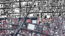
Over the past 15 years, geospatial information has enabled the transformation of towns, cities and a whole state in Mexico. The customer and data provider teamed up to create up-to-date...
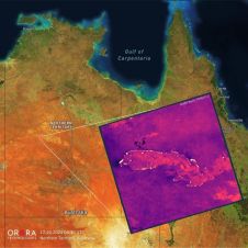
UP42 and OroraTech have signed a partnership agreement to grant easy and fast access to global high-resolution thermal-infrared imagery. UP42 is a geospatial developer platform and marketplace, and OroraTech is...
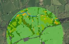
The UK’s Peak District National Park Authority is pioneering the use of artificial intelligence (AI) to automate the production of highly detailed land cover maps, in a project in partnership...
Cadastre & Land Administration Geospatial data obviously is key to sustainable land management. But what are the common success factors for land administration and cadastral systems around the world? In this issue, we will...

Arkadiusz Szadkowski is senior business development manager of reality mapping, imagery & remote sensing at Esri. He is passionate about leading the change towards 3D GIS and bridging the gap...

Both vertical and oblique aerial images have their own advantages, making them valuable in different reality mapping applications. So how can you choose between the two? This comparison will help...
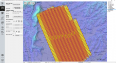
The TatukGIS Developer Kernel (DK) plays a key role in the Topoflight software suite (Missionplanner for optimal flight paths, and Navigator for precise data acquisition). In the realm of vast...

In the rapidly evolving landscape of geospatial technology, the annual Trimble Dimensions gathering is a dependable beacon for the surveying and mapping fields, providing a panoramic view of the current...

In a groundbreaking collaboration, Genesys International and Survey of India (SOI) have formed a strategic alliance to create digital twins of major cities and towns. This partnership is aimed at...

Intergeo 2023 was an electrifying three-day event in Berlin, transforming the city into the global geospatial capital. From 10-12 October, professionals from across the globe convened for the world’s premier...
This site uses cookies. By continuing to use this website, you agree to our Cookies Policy. Agree