Found 3468 results
Sort by

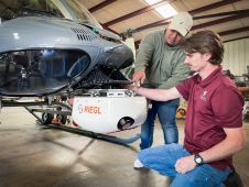
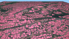
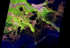
CHCNav introduces AlphaUni 20 Lidar system

The AlphaUni 20 (AU20) Lidar system represents a new era in cost-effective, multi-platform mobile mapping solutions, according to CHC Navigation (CHCNav), a global leader in precision mapping, positioning and navigation...

Read more

Preserving history in the high Arctic

Nestled in the high Arctic Archipelago of Svalbard, the Sveagruva coal mine and mining settlement once buzzed with activity until its closure in 2016. An extraordinary project is now underway...

Read more

Using AI for good

Humanitarian organizations turned to artificial intelligence (AI) to generate a comprehensive map of sub-Saharan Africa at scale and also keep it updated to reflect real-world changes. Geospatial analysis is a...

Read more