Spatial Initiatives for Sustainable Land Management
Access to land and other natural resources is an important basis for the livelihood of underprivileged people around the globe. Access must be stable and secure if it is to...
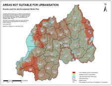
Access to land and other natural resources is an important basis for the livelihood of underprivileged people around the globe. Access must be stable and secure if it is to...
PlanetScope is now accessible on Google Cloud Marketplace. This availability of Planet's flagship satellite imaging product contributes to the company's mission to democratize access to near-daily satellite imagery, enabling organizations...
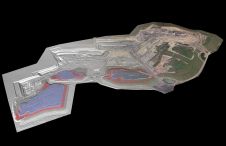
At Geo Week 2024 in Denver, Maptek unveiled its latest innovation: Maptek GeoSpatial Manager. This groundbreaking solution simplifies and streamlines workflows, revolutionizing how mining and civil engineering projects manage data...
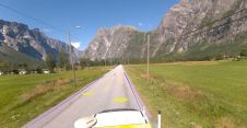
Field and Mosaic have jointly developed an advanced mobile mapping solution for road network management. Thanks to this successful collaboration, road asset managers and owners can now explore and interrogate...
The full feature is online at http://member.gim-international.com/. Please subscribe for free using the Subscribe button in the left hand column. While legislation has been introduced to improve land management and...
The British Columbia (BC) Integrated Land Management Bureau is adding additional Galdos (a product of Galdos Systems, Canada) components to its current spatial database environment called the iTRIM (intelligent Terrain...

Linda Foster oversees Esri’s worldwide strategic vision for land administration and surveying. With 20 years of experience working in the land and resource industry, she is a registered professional land...

There are indications that today’s technological advances are putting a fully operational multipurpose cadastre within reach, following decades of a global vision and small-scale progress towards a comprehensive map-centric land...

Intermap has won a US$20 million contract to map the Indonesian island of Sulawesi this year. The contract is the first phase of the Indonesian national topographic basemap programme to...
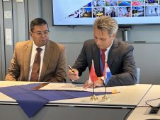
Dutch Kadaster and the Indonesian National Land Agency have signed a new Memorandum of Understanding (MoU). The two parties have been collaborating on the modernization and digitalization of land registration...
This site uses cookies. By continuing to use this website, you agree to our Cookies Policy. Agree