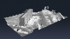
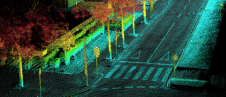
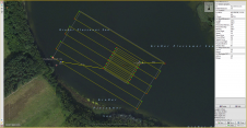
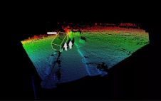
The EvoLogics Multibeam, a new multibeam echosounder option for the Sonobot 5 platform, was released at Ocean Business in Southampton, UK, in April this year. In May, EvoLogics conducted its final trials at one of the company’s regular testing sites the Plessower Lake in Brandenburg, Germany. The company is now taking the Sonobot 5 on a summer demonstration tour for partners and clients so that they can see its efficiency and effectiveness for underwater mapping for themselves. The EvoLogics Multibeam, a new multibeam echosounder option for the Sonobot 5 platform, was released at Ocean Business in Southampton, UK, in April this year. In May, EvoLogics conducted its...