Supporting urban spaces with UAV mapping and 3D modelling
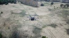
A team from Greece studied the use of aerial imagery to achieve wide coverage of a predefined geometrical area of interest in a project to explore the contribution of UAVs...
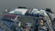
A team from Greece studied the use of aerial imagery to achieve wide coverage of a predefined geometrical area of interest in a project to explore the contribution of UAVs...

In this article, we’ll talk about why it’s time to invest in a mobile mapper, and how these cutting-edge tools can transform your day-to-day work. In this article, we’ll talk about why it’s time to invest in a mobile mapper, and how these cutting-edge tools can transform your day-to-day work. Whether you’re an independent contractor,...
The new state-of-the-art Phase One P5 128MP camera has been seamlessly integrated into Quantum Systems’ flagship Trinity Pro mapping drone and the leading surveying workflow, Trimble Business Center. The resulting purpose-built,...

Take control of the way you work. Scanning, imaging, processing, and sharing at speed and scale. Trimble Mobile Mapping technology unlocks the next generation of geospatial projects. Learn More→
Trimble has announced a partnership with the HALO Trust, the world’s largest landmine-clearing non-profit organization, to help expand its demining operations across Ukraine. The grant from the Trimble Foundation Fund...
Topodrone has announced the integration of its Lidar Prime scanner with the aOrion Heli-E UAV enabled by Velodyne’s Alpha Prime sensor. This is aimed at bridging the gap in UAV-based...
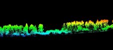
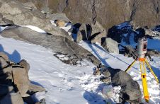
The use of UAV-Lidar is being tested in the complex terrain of the Chernobyl Exclusion Zone. The aim of the University of Bristol team is to demonstrate that, in the...
A project in Aotearoa/New Zealand is combining the use of high-quality DEMs from satellite photogrammetric mapping (SPM) with Lidar technologies to model hazards such as snow avalanches. The resulting topographic...
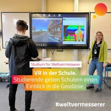
The German Association for Geodesy (DVW) has launched a campaign to build young people’s awareness of the exciting career opportunities in the geospatial industry. The world of geoinformation is diverse,...
Southern Mapping Company (SMC) has purchased Optech Incorporated\'s new ALTM (Airborne Laser Terrain Mapper) Orion sensor. This purchase makes Southern Mapping Company the first commercial owners of the world\'s smallest,...
This site uses cookies. By continuing to use this website, you agree to our Cookies Policy. Agree