Detlef Angermann
Detlef Angermann holds a doctorate in Geodesy and heads the Focus Area Reference Systems at the Deutsches Geodätisches Forschungsinstitut (DGFI-TUM) of the Technical University of Munich. His research focuses on...

Detlef Angermann holds a doctorate in Geodesy and heads the Focus Area Reference Systems at the Deutsches Geodätisches Forschungsinstitut (DGFI-TUM) of the Technical University of Munich. His research focuses on...
Calling all professionals! Please contribute to the 2024 edition of the annual geospatial industry survey by GIM International, which is currently in progress. This yearly tradition serves as a valuable...

Global reference systems such as the International Terrestrial Reference Frame provide the foundation for determining positions on Earth and in space, as well as for reliably quantifying our planet’s changes...
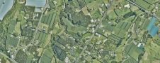
Land Information New Zealand has made 20TB of aerial imagery available for free for the first time in a cloud-optimized format on Amazon Web Services (AWS), making it easier and...

The city of Zagreb has been developing a semantic 3D city model since 2008. The city spatial planning sector was recognized as the main project user and developer, while more...
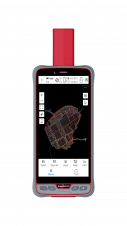
ComNav Technology has introduced its new handheld P6H. This advanced and rugged device is tailor-made for GIS data collection and outdoor operations. Featuring a GNSS high-precision positioning module, rugged IP67-rated...

GrabMaps is preparing to launch KartaCam 2, a crowdsourced mapping solution combining high-end imagery and AI capabilities to transform local expertise into effective navigation solutions. With the introduction of enhanced...

Over the past 20 years, various initiatives have been launched reflecting the importance of cadastral data for land management and spatial development. But how have these initiatives enhanced the possibility...
Blue Marble Geographics has released GeoCore 2.0, the conversion developer tool kit for geospatial data. The updated version of GeoCore includes the latest versions of GeoTransform, GeoCalc, and GeoTranslate software...
This site uses cookies. By continuing to use this website, you agree to our Cookies Policy. Agree