JOUAV unveils advanced airborne Lidar sensor
JOUAV has released the JoLiDAR-1000 Lidar sensor designed specifically for uncrewed aerial vehicles (UAVs or ‘drones’) as the latest addition to its array of high-performance Lidar sensors for use in...

JOUAV has released the JoLiDAR-1000 Lidar sensor designed specifically for uncrewed aerial vehicles (UAVs or ‘drones’) as the latest addition to its array of high-performance Lidar sensors for use in...

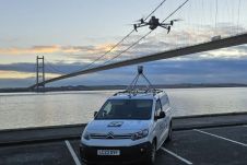
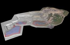
A topobathymetric Lidar survey was conducted to support flood preparedness in Canada. Which techniques achieved exceptional precision, and what were the logistical challenges? Find out more in this article. As...
Mosaic has partnered with Movella aimed at redefining precision and efficiency in mapping and 3D reconstruction projects. Mosaic is specialized in mobile mapping camera systems, while Movella is a renowned...

Topcon Positioning Systems has expanded its support for the Get Kids into Survey (GKiS) project, now serving as the exclusive sponsor of the Global Brand Ambassador Hub. This new platform...

Visitor registration is now open for GEO Business, the UK's largest geospatial event. The free-to-attend expo, tailored for geospatial professionals seeking to harness the potential of location intelligence, will return...
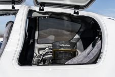
Diamond Aircraft and Vexcel Imaging have announced the next collaboration for a further expansion of Diamond’s special mission aircraft high-end sensor portfolio. The partnership will integrate the UltraCam Dragon 4.1...
Make Underwater Exploration Easier Focus on acoustic sounding technology, Hydro-Tech had developed different products widely applied in underwater exploration industry. Nowadays Hydro-Tech owns completely independent and controllable core technologies in...
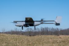
In a new strategic partnership, Inertial Labs' RESEPI Payload Lidar technology will be integrated into E38's advanced E455 drone platform. This collaboration marks a significant milestone in the utilization of...
At Geo Week 2024 in Denver, Maptek unveiled its latest innovation: Maptek GeoSpatial Manager. This groundbreaking solution simplifies and streamlines workflows, revolutionizing how mining and civil engineering projects manage data...
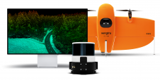
Wingtra has unveiled its innovative Lidar-drone solution. The new Lidar payload is designed to seamlessly integrate the efficiency, ease of operation, and high accuracy of the WingtraOne GEN II drones...
This site uses cookies. By continuing to use this website, you agree to our Cookies Policy. Agree