Shining a Light on the Surveying Profession
Besides its excellent technical content, the recent FIG Congress in Poland was a place for enthusiastic reunions and for forming new friendships. Wim van Wegen looks back on the event,...

Besides its excellent technical content, the recent FIG Congress in Poland was a place for enthusiastic reunions and for forming new friendships. Wim van Wegen looks back on the event,...
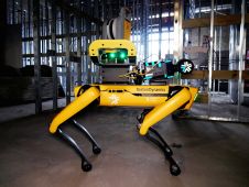
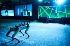
Trimble and Exyn Technologies, a pioneer in multi-platform robotic autonomy for complex, GPS-denied environments, have entered a strategic collaboration to explore the use of autonomous construction surveying technology. The solution...

The vibe at Intergeo 2022 felt almost just the same as pre-pandemic times, and a wide range of innovative hardware and software solutions were on display. The geospatial industry is...

The members of DVW have unanimously elected Prof Rudolf Staiger as the next president. He will succeed Prof Hansjörg Kutterer who has held the role since 2016. Staiger will take...
What are the key challenges in establishing precise geodetic control networks? This is one of the most important tasks of geodesists and land surveyors, since geodetic control networks are essential...
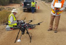
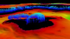
In recent years, the UAV has outgrown its status as a disruptor to become a standard part of the surveyor’s toolkit for capturing the environment. One thing that makes the...

Benjamin Sattes started his geodetic path in 2001 as a surveying technician. He then pursued this direction by studying surveying at HFT Karlsruhe, Germany. Right after graduating in 2009, he...

In a short ceremony, the outgoing president of FIG (International Federation of Surveyors), Rudolf Staiger, handed his presidency over to incoming president Diane Dumashie. The symbolic event took place at...
In which direction is the geospatial industry heading? Which core activities will companies focus on? How will the rapidly progressing technological advances shape the future? The recent edition of HxGN...
Hydrographers are increasingly aware of the added value that a Lidar (Light Detection and Ranging) scanner can bring to bathymetry survey operations. The Teledyne Optech Polaris Laser Scanner, for example,...
This site uses cookies. By continuing to use this website, you agree to our Cookies Policy. Agree