Lidaretto
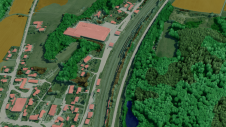
Lidaretto is flexible and compact Lidar scanning system developed since 2015 and uniquely designed to be used the way that fits best to users’ specific application. You can easily mount...

Lidaretto is flexible and compact Lidar scanning system developed since 2015 and uniquely designed to be used the way that fits best to users’ specific application. You can easily mount...

GrabMaps is preparing to launch KartaCam 2, a crowdsourced mapping solution combining high-end imagery and AI capabilities to transform local expertise into effective navigation solutions. With the introduction of enhanced...

Dublin City University (DCU) has partnered with Bentley Systems to spearhead the creation of an advanced digital twin of its campus as a pivotal element of its Smart DCU initiative....

A man who received a 360-degree camera as a gift has taken it upon himself to incorporate his neighbourhood in Guernsey into the Google Street View online map, according to...
Innovative methodologies based on artificial intelligence (AI) are lowering the barriers and democratizing the use of 3D digital twins in the geospatial industry. Digital twins are revolutionizing the geospatial industry,...
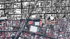
Over the past 15 years, geospatial information has enabled the transformation of towns, cities and a whole state in Mexico. The customer and data provider teamed up to create up-to-date...

Kristen Maglia is senior product marketing manager at Esri. She started her marketing career in imagery analysis software immediately after graduating from Colorado State University, and has had the unique...

Arkadiusz Szadkowski is senior business development manager of reality mapping, imagery & remote sensing at Esri. He is passionate about leading the change towards 3D GIS and bridging the gap...

Both vertical and oblique aerial images have their own advantages, making them valuable in different reality mapping applications. So how can you choose between the two? This comparison will help...
In the rapidly evolving landscape of geospatial technology, the annual Trimble Dimensions gathering is a dependable beacon for the surveying and mapping fields, providing a panoramic view of the current...
This site uses cookies. By continuing to use this website, you agree to our Cookies Policy. Agree