
Elevating knowledge: read our in-depth features

I love to listen to tech podcasts that cover new gadgets or services. I’m not a big gadget person, but I love to think through the problem that a new product or service solves. I heard about some ne...
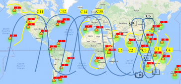
Currently there are four global navigation satellite systems (GNSSs) available: GPS, Glonass, BeiDou and Galileo. The satellites of these systems are used for positioning, and the accuracy is greatly ...

The demand for 3D maps of cities and road networks is steadily increasing and mobile mapping systems are often the preferred acquisition method for capturing such scenes. Manual processing of point cl...

As users push for more capabilities, today’s location apps for smartphones and tablets are running up against frustrating limitations. Higher accuracy can increase the performance of location-aware ...

To increase capacity at Pangnirtung Airport, situated in a remote mountainous region of northern Canada, one solution could be to relocate the airport to one of two nearby sites. This article provides...

Diverse environmental effects, climatic changes and human alterations of the ecosystems are deeply changing Earth’s surface processes and creating environmental challenges that researchers are strug...

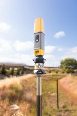
Geneq has announced the introduction of SXblue GLOBE, representing a new step in innovation for GNSS positioning and GIS technology. Engineered to be employed in the most challenging field conditions,...

Septentrio’s collaboration with major drone solutions providers is driving new products allowing easier prototyping or integration of its Mosaic GNSS receiver into uncrewed aerial vehicles (UAVs or ...

SingularXYZ has presented its latest innovation for geospatial professionals: the X1 Pro GNSS receiver. This new device aims to refine precision in surveying technology with a range of features tailor...
Topcon Positioning Systems has presented the latest addition to its HiPer family of global navigation satellite system (GNSS) receivers. The HiPer CR is a compact and lightweight GNSS receiver designe...
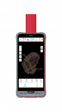
ComNav Technology has introduced its new handheld P6H. This advanced and rugged device is tailor-made for GIS data collection and outdoor operations. Featuring a GNSS high-precision positioning module...
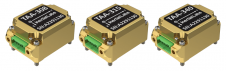
Inertial Labs has unveiled its latest innovation: high-precision three-axis accelerometers (TAA). These compact, self-contained devices mark a significant leap forward in navigation-grade acceleromete...

Our weekly newsletter is an easy way to stay updated with our latest articles, news, and magazines. It's the easiest way to stay current with the industry.
Subscribe to our newsletter(s)Positioning, in its essence, represents the meticulous process of accurately determining the spatial location of an object concerning a specific framework or datum. This fundamental concept of positioning plays an indispensable role in the domains of geography and hydrography, persistently guiding the quest to pinpoint the precise locations of the objects and features we seek to measure and understand.
Depending on the specific application at hand, the framework within which positioning occurs can be either of a global or local nature. When thinking on a global scale, the utilization of advanced techniques like Global Navigation Satellite Systems (GNSS) comes into play. In this scenario, the framework for positioning is meticulously defined by geodetic coordinate reference systems, ensuring the utmost accuracy in spatial determinations on a planetary scale.
Conversely, in more localized settings, positioning takes on a distinct character, tailored to the unique demands of specific tasks. For instance, in the realms of construction and engineering, the precision of positioning is paramount, and it's achieved through instruments such as the Total Station, allowing for the highly accurate alignment and placement of structures and infrastructure. Meanwhile, indoor navigation is another intriguing facet of local positioning, where the frameworks are often established within the confines of buildings, where technologies like indoor positioning systems enable precise and efficient navigation.
As we delve deeper into the world of positioning, it becomes evident that this art and science of location determination extends its influence far and wide, offering versatile solutions for diverse applications, all while maintaining an unwavering commitment to spatial accuracy.
This site uses cookies. By continuing to use this website, you agree to our Cookies Policy. Agree