Mapping with Mobile Lidar
The use of Mobile Lidar systems enters the scene when large areas have to be surveyed at accuracy and resolution exceeding those available through aerial photogrammetry, and when using static...
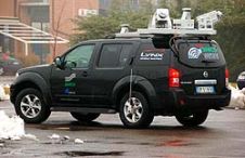
The use of Mobile Lidar systems enters the scene when large areas have to be surveyed at accuracy and resolution exceeding those available through aerial photogrammetry, and when using static...
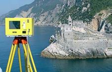
When surveying the coastline, the integration of bathymetric (below sea level) and laser scanning (above sea level) data causes problems due to the different imaging properties. However, by ensuring that...
Intergeo, the world’s largest congress and trade-fair for geodesy, geoinformation and land management, will this year be held in Karlsruhe, Germany, from 22nd to 24th September. About 16,000 visitors are...
Contex has released Nextimage, a new generation multi-function software solution. The powerful software for wide format scanners makes scanning tasks faster with an intuitive user interface and advanced imaging features....

Changing the way people acquire, analyse, visualise and disseminate geospatial information is the ambition of Vexcel Imaging GmbH, manufacturer of UltraCam and provider of remote-sensing technologies. Based in Graz, Austria,...
The eight new Technical Commission presidents elected at the ISPRS Congress in Beijing in July 2008 have set up the Working Groups that will carry out their commissions' technical programme....
Carlson Software (KY, USA) has released Carlson Survey 2009 Embedded AutoCAD. This version has the AutoCAD OEM engine built-in, which is in addition to the Carlson Survey 2009 for AutoCAD...

DIMAC Systems has unveiled during the INTERGEO 2008 the DiMAC ULTRALiGHT, the smallest of the DiMAC (Digital Modular Aerial Camera) product family. It consists of just a single Camera Module...
The geomatics profession is implicated in several ISO standards. The important ISO9001: 2000 prescribes regular instrument testing and calibration. To help meet required stringent alignment tolerances, a modern calibration bench...
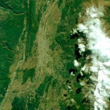
The first public release of a RapidEye image has been unveiled. This demonstration image highlights the capabilities of RapidEye imagery in many market segments, by showing diverse landscapes that include...
This site uses cookies. By continuing to use this website, you agree to our Cookies Policy. Agree